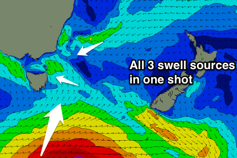
Small mix of swells with some bigger developments likely next week
Eastern Tasmania Surf Forecast by Craig Brokensha (issued Monday 27th February)
Best Days: Wednesday morning, Thursday morning, Saturday morning
Recap
A poor weekend for surfing with no decent swell to get stuck into. This morning remained tiny and poor.
This week and weekend (Feb 28 – Mar 5)
The setup that's responsible for our expected run of E/NE-NE swell this week is currently taking shape, with a weak but broad and persistent fetch of strong E/NE winds now forming through the central Tasman Sea, extending also above New Zealand into the Coral Sea.
While not overly strong its persistence will generate small and fun levels of E/NE swell over the coming week, while a deepening low off the southern NSW coast Friday will add some additional SE swell into the mix come the weekend.
 Looking at the E/NE energy though and we should see open beaches building to 2ft tomorrow afternoon, persisting Wednesday with possibly the odd bigger one in the mix, with Thursday due to see the strongest increase to 2-3ft.
The swell should then drop back to the 2ft range from Friday through the weekend, but some new SE tending E/SE swell looks to come in around a similar size.
A sneaky S'ly groundswell pulse is also due later Friday and Saturday morning, produced by a strong low forming along the polar shelf mid-late this week. The size off this low doesn't look to be above the mix of E/NE and SE swells though.
Conditions each morning are looking favourable with NW breezes over the coming few days, N/NE into Tuesday and Wednesday afternoons, with a S/SE change Thursday. Friday then looks poor with gusty S/SE tending SE winds, light offshore again Saturday morning.
Longer term we've got some better swell developments on the cards for next week, with a stronger low likely form in the Tasman Sea, generating some large swell, but more on this Wednesday.

