Fun S/SE groundswell for Saturday
Eastern Tasmania Surf Forecast by Craig Brokensha (issued Friday 17th February)
Best Days: Saturday morning
Recap
Tiny surf yesterday and this morning, but keep an eye out for a new S/SE groundswell this afternoon.
This weekend and next week (Feb 18 - 24)
This afternoon's expected increase in S/SE groundswell, from a polar fetch of severe-gale to storm-force SE winds, should come in around a similar 2-3ft early tomorrow morning before easing off slowly through the afternoon, further from 1-1.5ft Sunday morning.
The more dominant NE swell showing on the forecast graph is still looking dicey for me, with the fetch generating this sitting off the southern NSW coast and not directly close to us.
 With this we may see 1-1.5ft sets tomorrow at north magnets, fading Sunday.
Conditions look great over the weekend with a moderate W/NW tending variable breeze tomorrow, similar Sunday.
Monday is looking tiny, but a weak low moving over us through the afternoon should produce a fetch of strong S'ly winds right off our coast, generating a small S'ly swell for Tuesday. South facing beaches are expected to see 1-2ft sets early, fading through the day along with W'ly offshore and NE sea breezes.
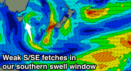
A weak fetch of S/SE winds further away from us on Monday evening should keep 1-2ft sets hitting magnets Wednesday morning before fading through the day.
Into Wednesday afternoon and Thursday, a strong frontal system approaching from the west will squeeze a high in the Tasman Sea, generating a strengthening N/NE fetch through our swell window, kicking up a small to moderate sized N/NE windswell Thursday morning.
This could be with an offshore change, but the timing of this is still unsure. Check back Monday for more details. Have a great weekend!

