Small S/SE swell all week, NE swell also tomorrow
Eastern Tasmania Surf Forecast by Craig Brokensha (issued Monday 23rd January)
Sign up to Swellnet’s newsletter and receive the Eastern Tasmania Forecaster Notes and latest news sent directly to your inbox. Upon signup you'll also enter the draw to win a surf trip to P-Pass for you and a mate (this is the last week to enter). It doesn’t get much easier so click HERE to sign up now.
Best Days: Tuesday, every morning this week
Recap
Good solid amounts of easterly swell hanging in from Friday's stormy increase with easing 3-4ft sets out of the east.
Sunday then saw a new S/SE groundswell pulse to 2-3ft with offshore winds again.
The swell has dropped back into this morning leaving tiny 1-1.5ft waves on the coast.
This week and weekend (Jan 24 - 29)
Our final pulse of S/SE groundswell due across the coast tomorrow afternoon is still on track, produced over the weekend by a final fetch of SE winds aimed towards us. Inconsistent 1-2ft sets are due across exposed breaks from tomorrow afternoon through the rest of the week, fading later Friday.
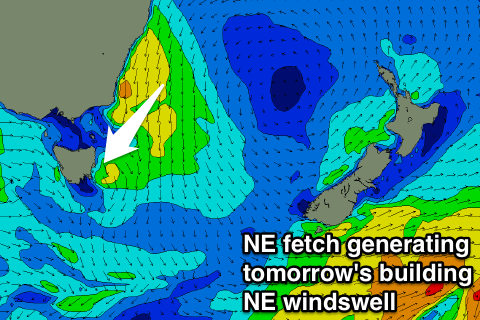
Some small NE windswell should also be in the mix tomorrow midday/afternoon, produced by a strong and broad fetch of NE winds developing off the southern NSW coast this afternoon and evening.
 We should see north facing breaks reaching 2ft to nearly 3ft through the day, easing later and more so Wednesday.
Winds are due to swing from the W/NW to W/SW through tomorrow as a strong front pushes through, with W/NW tending NE winds on Wednesday.
Morning offshores will continue through Thursday and Friday, with no significant swell due for the rest of the period.
Longer term some small S'ly groundswell may be seen mixed in with some small NE windswell next week, but more on this Monday.

