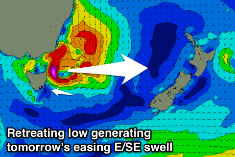
Good fun weekend with a mix of swells
Eastern Tasmania Surf Forecast by Craig Brokensha (issued Friday 20th January)
Sign up to Swellnet’s newsletter and receive the Eastern Tasmania Forecaster Notes and latest news sent directly to your inbox. Upon signup you'll also enter the draw to win a surf trip to P-Pass for you and a mate (there's only 1 week left to enter). It doesn’t get much easier so click HERE to sign up now.
Best Days: Saturday, Sunday, early Monday, Wednesday morning, Thursday morning
Recap
The S/SE pulse came in nicely yesterday to 2-3ft, while today a very intense low forming off the southern NSW coast projected E/NE gales into us, kicking up a rapid increase in stormy E/NE swell, but since then a S'ly change has moved through, creating clean waves in southern corners.
This weekend and next week (Jan 21 - 27)
The low responsible for today's swell and winds will move off quickly to the east tomorrow, with a rapidly easing E/SE swell from 3ft at open beaches.
 Also in the mix should be inconsistent levels of S/SE groundswell from the fetch stalling off the polar shelf over the past few days, coming in at 2ft all day, peaking Sunday to 2ft to maybe 3ft before fading Monday.
Conditions should be clean each morning over the weekend, even into the early afternoon ahead of sea breezes.
The reinforcing and final pulse of S/SE groundswell for Tuesday through Thursday is now looking a little hit and miss, with the final re-intensification of the SE fetch, south of New Zealand being a bit weaker than forecast on Wednesday.
We're only looking at inconsistent 1-2ft sets through this period (later Tuesday through Thursday) at swell magnets.
Other than this, the outlook remains poor for swell, so try and surf over the weekend.

