Small flukey swells over the coming period
Eastern Tasmania Surf Forecast by Craig Brokensha (issued Wednesday 18th January)
Sign up to Swellnet’s newsletter and receive the Eastern Tasmania Forecaster Notes and latest news sent directly to your inbox. Upon signup you'll also enter the draw to win a surf trip to P-Pass for you and a mate (there's only 2 weeks left to enter). It doesn’t get much easier so click HERE to sign up now.
Best Days: Early Thursday open beaches, southern corners Friday afternoon, Saturday morning, Sunday morning, Tuesday morning, Wednesday morning
Recap
Nothing of note yesterday, while today some small inconsistent S/SE groundswell was showing across the coast.
A new S'ly swell should also be building but with average winds.
This week and weekend (Jan 19 - 22)
Currently a strong cold front is pushing up past our coast into the Tasman Sea while generating a fetch of strong SW winds.
A small kick in S'ly swell is due off this front, peaking overnight and easing from 2ft to maybe 3ft at south magnets tomorrow morning.
Our small persistent S/SE groundswell for the period hasn't changed, but today should of revealed more size than was reported.
We're seeing a fetch of strong SE winds aimed at us from the polar shelf, and this fetch while weakening slightly Thursday evening, is expected to re-intensify and broaden Friday evening and Saturday, before shifting east away from us.
 Inconsistent levels of S/SE swell should come in around an 2ft at magnets from tomorrow through the weekend (possibly a little bigger Saturday and Sunday morning before easing off Monday.
One final pulse is then due Tuesday and Wednesday again to 2ft or so, fading Thursday.
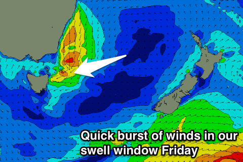
During Friday a quick and rapid increase in NE tending E/NE swell is also due as a low forms off the southern NSW coast, directing a burst of strong to gale-force NE tending E/NE winds through our swell window.
Open beaches are due to reach a messy 3ft to maybe 4ft, but conditions will be poor with strong E/NE tending S/SE winds.
Early next week some small N/NE swell is due to be in the mix Monday afternoon, but only to 1-2ft or so, fading Tuesday.
Winds tomorrow are average with a SW tending E'ly winds, while Friday also looks poor as pointed out above.
Cleaner conditions are then due Saturday and Sunday mornings, with N'ly breezes Monday.
Longer term there's nothing too major on the cards, but more on this Friday.

