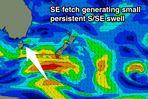
Small persistent S/SE swell
Eastern Tasmania Surf Forecast by Craig Brokensha (issued Monday 16th January)
Sign up to Swellnet’s newsletter and receive the Eastern Tasmania Forecaster Notes and latest news sent directly to your inbox. Upon signup you'll also enter the draw to win a surf trip to P-Pass for you and a mate (there's only 2 weeks left to enter). It doesn’t get much easier so click HERE to sign up now.
Best Days: Every morning over the coming period at south swell magnets (excluding Thursday)
Recap
Tiny surf on Saturday and Sunday morning but into the afternoon a good pulse of S'ly groundswell filled in across south magnets. The swell peaked overnight and dropped back a bit into this morning, with smaller waves into this afternoon.
This week and weekend (Jan 17 - 22)
This forecast period we'll see small inconsistent amounts of persistent S/SE swell due across the coast.
 This is related to a fetch of strong SE winds on the polar shelf around the backside of the low moving through over the weekend.
The fetch that's currently aimed at us will weaken a shift away through this evening, but then following this a new persistent SE fetch will develop tomorrow and persist through until the weekend.
What we can expect is a small fun S/SE swell to arrive Tuesday afternoon, peaking Wednesday and Thursday around 2ft to possibly 3ft before easing Friday.
A new reinforcing pulse to a similar size is expected through Saturday, easing slowly from Sunday.
Also in the mix Thursday is expected to be some short-range S'ly swell from a polar front pushing up and past us, and this should provide 2-3ft sets at south magnets early, easing through the day.
Winds the next two mornings are great with offshores due, but Thursday a less favourable and early SW'ly will swing SE through the day and then Friday morning will be back to an early NE'ly.
Each morning over the weekend looks clean as well, but more on this Wednesday.

