Flukey N/NE swell Friday, better S'ly swell Monday
Eastern Tasmania Surf Forecast by Craig Brokensha (issued Wednesday 11th January)
Sign up to Swellnet’s newsletter and receive the Eastern Tasmania Forecaster Notes and latest news sent directly to your inbox. Upon signup you'll also enter the draw to win a surf trip to P-Pass for you and a mate. It doesn’t get much easier so click HERE to sign up now.
Best Days: Late afternoon Friday north magnets, Monday
Recap
No real waves the last few days with tiny amounts of swell.
This week and weekend (Jan 12 - 15)
Tiny surf is expected tomorrow, with an intense low passing under the south of the state this morning being too zonal to generate any S'ly swell for us.
Friday's N/NE swell is looking a little dicey, with the strength of the fetch down the coast being impressive but the direction is straight northerly.
This will mean only small levels of N/NE swell will spread out radially into north facing breaks through the middle of the day/early afternoon, reaching 2ft+ or so and with N'ly winds, tending more NW mid-late afternoon (not the best combination).
 The strength of the change will be so much that there'll be no swell left into Saturday morning.
Of greater importance is the strong mid-latitude low moving across us over the weekend.
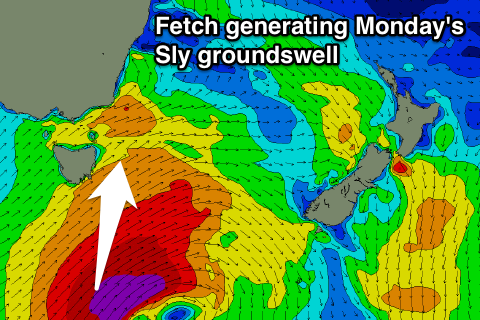
The secondary stages of the low are most interesting to us, with a fetch of severe-gale to possibly S/SW winds due to be generated through our southern swell window Saturday afternoon and evening.
This will be as the low slightly stalls between us and New Zealand, and we can expect a large S'ly groundswell from this, building very late Sunday but showing more so Monday.
At this stage we're looking at sets to 5-6ft out of the south, but we'll have to have another look at this on Friday.

