Small NE swell Friday, better S'ly swell Sunday/Monday
Eastern Tasmania Surf Forecast by Craig Brokensha (issued Monday 9th January)
Sign up to Swellnet’s newsletter and receive the Eastern Tasmania Forecaster Notes and latest news sent directly to your inbox. Upon signup you'll also enter the draw to win a surf trip to P-Pass for you and a mate. It doesn’t get much easier so click HERE to sign up now.
Best Days: Friday afternoon, Monday south swell magnets
Recap
Tiny Saturday, but Sunday saw some fun NE windswell with decent winds. This morning the NE swell was back to 1-2ft but nice and clean.
This week (Jan 10 - 13)
No major NE swell is expected tomorrow, with tiny leftovers, and through the rest of this week there's nothing major due at all.
A very intense mid-latitude low passing under the south coast Wednesday will be too zonal to generate any major size, while a weaker trailing fetch of W/SW winds may generate 1-1.5ft of south swell at magnets later Thursday and early Friday.
Besides this Friday should reveal a rapid increase in N/NE swell as a strong fetch of N/NE winds develop down our coast through the morning.
 A kick to 2ft+ is due through the late morning/early afternoon as winds swing offshore, tiny into Saturday.
This weekend onwards (Jan 14 onwards)
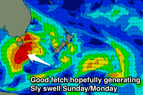
Into the weekend a much stronger cold outbreak is due to move across us, with a better aligned and stronger fetch of SW gales projecting past the south-east corner of the state.
This should generate a surfable pulse of S'ly swell, firstly refracting hard Sunday and coming in at 3ft across magnets ahead of a better S'ly pulse Monday morning more to 3-4ft. This will be with offshore NW winds, but we'll have to have another look at this on Wednesday.

