Flukey N/NE windswell Thursday, better S'ly swell to follow
Eastern Tasmania Surf Forecast by Craig Brokensha (issued Monday 5th December)
Sign up to Swellnet’s newsletter and receive the Eastern Tasmania Forecaster Notes and latest news sent directly to your inbox. Upon signup you'll also enter the draw to win a surf trip to P-Pass for you and a mate. It doesn’t get much easier so click HERE to sign up now.
Best Days: Thursday early afternoon, Saturday south swell magnets
Recap
A small and inconsistent SE swell to 1-2ft on Saturday morning, hanging in early Sunday before fading through the day.
Today a small fun NE windswell was easing across the coast with offshore winds ahead of a S/SE change.
This week and weekend (Dec 6 - 11)
There's no major surf due until Thursday when a burst of strong N/NE winds develop down the southern NSW coast through our northern swell window before shifting more NW into the afternoon and away from us.
We should see a small increase in N/NE windswell through Thursday, tiny early, but reaching 2ft+ at north facing beaches during the day/early afternoon and then easing from late with the offshore change.
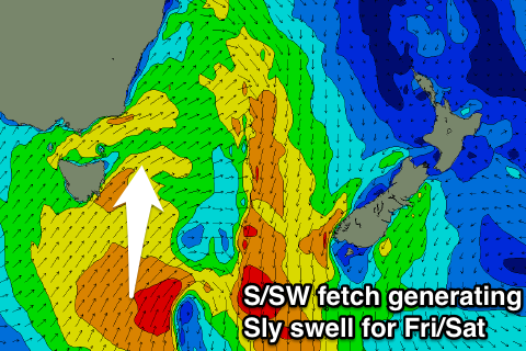
 Of greater importance is a vigorous cold front that's expected to move in behind the change, directing a great fetch of strong to gale-force S/SW winds from below us, up past our coast through Friday.
The front and fetch will be slow moving, which will help generate a moderate sized S'ly swell event, building Friday afternoon to 3ft+ across south facing beaches later in the day and easing from 3-4ft Saturday morning.
Winds will be average as the swell builds Friday and from the south, but Saturday should see favourable offshore W/SW tending variable winds.
After this we may see a secondary small S'ly swell early next week, but more on this Wednesday.

