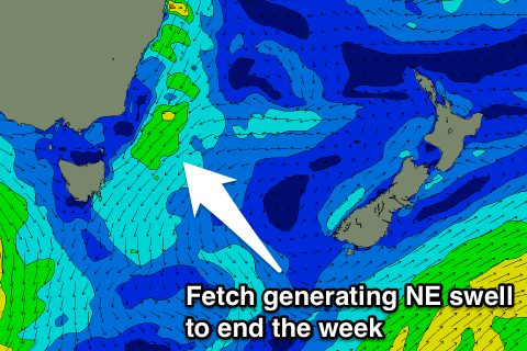
Diet of north-east swell from tomorrow
Eastern Tasmania Surf Forecast by Craig Brokensha (issued Wednesday 30th November)
Best Days: South magnets early tomorrow, open beaches Friday morning and Saturday morning, north-east magnets early Monday
Recap
Small clean 1-2ft waves yesterday morning, ahead of a kick in new swell through the afternoon. This swell has peaked through today with a variable wind through the morning, but sea breezes are now in across the coast.
This week and weekend (Dec 1 - 4)
Today's S/SE swell should ease through tomorrow from 2ft at south facing beaches, but a new NE windswell will be more noticeable, building through the day.
This will be produced by a small surface trough moving offshore, squeezing a high in the Tasman Sea.
 A fetch of strong and well aimed NE winds will be generated through our swell window from this evening through tomorrow before moving east and away from us Friday morning.
We should see north-east facing beaches building to 3ft later tomorrow with a moderate to fresh NE wind (lighter and N/NW early), easing quickly from a similar size Friday morning with offshore W/NW winds.
Come Saturday the swell will likely be fading from 1-1.5ft.
Our new inconsistent SE swell is still on the cards though with a fetch of strong E/SE winds south-east of New Zealand now currently easing. The swell should provide very inconsistent 2ft sets Saturday before easing Sunday.
Next week onwards (Dec 5 onwards)
A small spike in N/NE windswell is likely Monday morning from a burst of strong N/NE winds down the coast Sunday evening, with nothing of significance then onwards. More on this Friday though.

