Good improving N/NE windswell Friday, better SE groundswell on the cards for next week
Eastern Tasmania Surf Forecast by Craig Brokensha (issued Wednesday 19th October)
Best Days: Friday mid-morning onwards, early Saturday morning southern corners, Sunday morning, early next week
Recap
Tiny surf the last couple of days, but from Friday we've got a much more active period.
This week and weekend (Oct 20 - 23)
Tomorrow is due to remain tiny for most of the day besides a possible late increase in N/NE windswell.
Friday will however show much more potential, with a fetch of strong to gale-force N/NE winds due to develop off our coast Thursday evening and early Friday, kicking up moderate amounts of N/NE windswell.
 Solid surf in the 4ft range is expected across north facing breaks Friday morning, easing off steadily during the day as a W/NW change develops mid-morning followed by a S'ly change into the early evening.
Come Saturday morning we should still see 2ft+ sets across north facing beaches, fading quickly as some new S'ly windswell builds.
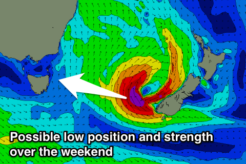
Fresh S/SW tending S/SE winds will accompany this building swell, with a low pressure system expected to stall and form to our east.
The models are still divergent around where this low is expected to form and stall, with the latest updates having it more to our south-east off New Zealand's South Island.
If this is the case, a small weak S'ly windswell Saturday afternoon will likely easing Sunday ahead of a strong pulse of SE groundswell Monday/Tuesday with favourable winds.
We'll have to have a closer look at this Friday though for more on the outlook.

