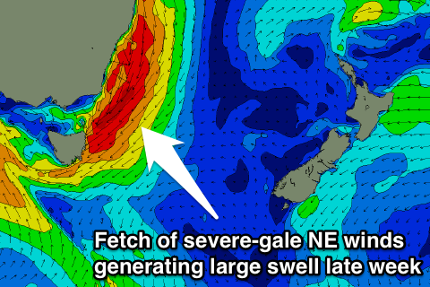
Large NE swell for the end of the week
Eastern Tasmania Surf Forecast by Craig Brokensha (issued Monday 26th September)
Best Days: Friday, Saturday
Recap
Great waves Saturday morning with 3-4ft+ of E/NE swell with early offshores, fading into the afternoon and further Sunday from a small 1-2ft or so. A bit smaller than expected, especially with a NE windswell in the mix.
Today was clean but tiny and easing from 1-1.5ft.
This week and weekend (Sep 27 – Oct 2)
The coming days will be tiny for the most part, with a possible uptick in E'ly energy to 1ft Wednesday.
 Of greater importance is a severe low forming in the Bight and then moving east through the end of the week.
As this low squeezes against a strong high pressure system to our east, a fetch of severe-gale NE winds will develop from Byron down to our coast on Thursday, generating a large NE groundswell.
This swell should start to build through Thursday, windswelly at first and growing in strength and size through the day. Dawn should see 1-1.5ft sets, building to a large 6ft+ late in the day but with gale-force E/NE winds.
The low will drift south-east on Friday morning and this will see the fetch swing more E/NE and then out of our swell window.
A rapid drop in swell is expected from the NE with 6-8ft sets at magnets early, back to 3-4ft into the afternoon. Saturday may see lingering levels of E/SE swell from the backside of the low to 3ft, fading Sunday.
Winds should swing offshore from the NW Friday morning ahead of NE sea breezes and then developing W'ly winds Saturday.
We'll confirm this on Wednesday though.

