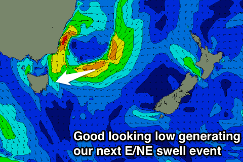
Another good pulse of E/NE swell on the way
Eastern Tasmania Surf Forecast by Craig Brokensha (issued Wednesday 21st September)
Best Days: Every morning over the coming period
Recap
Our good pulse of E/NE swell came in on forecast with clean 3-4ft sets across the coast through the morning.
A slight drop back to 2-3ft was seen today with good conditions again through the morning.
This week and weekend (Sep 22 - 25)
The slow moving low responsible for our current E/NE swell has been weakening while moving towards New Zealand the last couple of days.
A weak fetch of E'ly winds are still being aimed through our swell window though and this will keep fun amounts of E/NE swell hitting the coast tomorrow and Friday.
Open beaches should ease back from 2-3ft tomorrow morning with SW tending fresh S/SE winds.
 Some new E/NE swell will build over the top of the existing swell Friday as another deepening low moves offshore, aiming a fetch of strong to gale-force E/NE winds towards us tomorrow and Friday before weakening into the weekend.
This looks nearly identical to the low that generated yesterday's E/NE swell, but with it being a little close and longer lived.
We should see a strong kick in size Friday, reaching 3-4ft+ later in the day, easing back from a similar size Saturday morning.
Sunday morning should still see 3ft sets, with the surf easing into the afternoon, down further from 1-2ft Monday morning.
Conditions on Friday will be similar to Thursday with a SW tending weaker SE breeze. Saturday will be best early with a NW breeze, freshening from the N/NE through the day, while a W'ly change will push through Sunday, with SE winds possible into the afternoon.
Longer term there's nothing too major on the cards, so work around the coming E/NE swell event.

