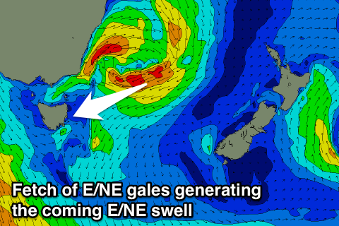
Good run of E/NE swell
Eastern Tasmania Surf Forecast by Craig Brokensha (issued Monday 19th September)
Best Days: Tuesday, Wednesday morning, Thursday morning, Saturday morning Sunday
Recap
Nothing of significance over the weekend and today's E/NE swell has been delayed a little, but it's on the cards for the coming days.
This week and weekend (Sep 20 - 25)
A deepening low that's pushed off the East Coast today has aimed a fetch of E/NE gales towards us. This fetch is slowly drifting east-southeast and will continue to be aimed in our swell window tomorrow before weakening over New Zealand tomorrow evening.
 This will generate good fun levels of E/NE swell from tomorrow through Wednesday and then easing off Thursday.
Open beaches should see solid 3ft+ sets most of tomorrow, persisting around 3ft Wednesday and then easing from 2-3ft Thursday.
Conditions look good tomorrow with W/NW tending N/NW winds, while Wednesday will be best early before fresh NE winds develop as another low starts to form and push east.
This low is expected to do nearly the same thing, generating a building E/NE swell for Friday afternoon, peaking Saturday to possibly 3-4ft. Conditions Thursday look clean early with a SW breeze, with possibly S/SE winds on Friday morning. Saturday then should offer NW tending N/NE winds ahead of a gusty W/SW change pushing through Sunday. More on this Wednesday.

