Good E/NE swell for early to mid next week

Eastern Tasmania Surf Forecast by Craig Brokensha (issued Friday 16th September)
Best Days: Tuesday, Wednesday morning
Recap
Good fun E'ly swell yesterday morning with offshore winds, and a late S'ly change kicked up a small S'ly swell for this morning. South magnets were the go for a wave, fading through this afternoon.
This weekend and next week (Sep 17 - 23)
Into the weekend we're not expected to see any real size across the coast, with S'ly swell energy for later tomorrow and Sunday being too west in nature to wrap into the coast.
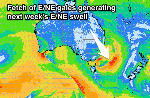 Into early next week, a good E/NE swell is on the cards, generated by a strengthening low drifting off the coast on Sunday and stalling in the Tasman Sea.
A fetch of E/NE winds will be aimed through our swell window while drifting slowly in a south-east direction.
A small fetch of gale-force E/NE to NE winds will be aimed towards us Sunday evening through Monday, generating a building E/NE groundswell for Monday, peaking Tuesday.
Open beaches should building to 2-3ft through the afternoon Monday, possibly larger later, and holding Tuesday around 3ft+ most of the day before easing Wednesday.
Conditions look best Tuesday morning, with afternoon sea breezes Monday and a W/NW tending N/NW breeze Tuesday. Wednesday will then see a S'ly change and building S'ly windswell but to no major size at this stage. We'll have a closer look at this Monday. Have a great weekend!