Tiny weekend, good S'ly swell Tuesday/Wednesday, E'ly swell mid-late week
Eastern Tasmania Surf Forecast by Craig Brokensha (issued Friday 19th August)
Best Days:
Recap
Tiny yesterday, but today some new N/NE windswell has built through the day and conditions are good at open beaches with winds swinging offshore late.
This weekend and next week (Aug 20 - 26)
Tomorrow morning the NE windswell should still be just in the water but fading quick with 1-1.5ft sets at dawn, tiny into the afternoon. Offshore W/NW winds will flatten it out.
 Our attention then turns to next week, with some good sources of swell on the cards.
A 'bombing low' that developed in the Bight is expected to drift slowly under us during the weekend, with a fetch of strong S/SE winds projecting slowly north through our southern swell window Sunday and Monday before tending more E/SE away from us Tuesday.
This should produce a good S'ly swell for Tuesday, building to 3-5ft across south facing spots, easing from a similar size Wednesday morning.
Conditions on Tuesday will be clean through the morning before NE breezes kick into the afternoon, favouring south magnets, with poor onshore strengthening E/SE winds through Wednesday.
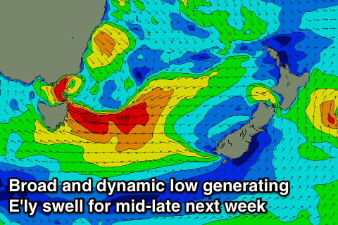
This strengthening onshore E/SE wind will be linked to a broad and deepening inland low, drifting south-east and off our coast during the middle of next week. This will likely see fetches of E'ly gales aimed towards us, but the models are still divergent on the structure. and embedded lows in such a dynamic system. Therefore check back here Monday for a much clearer idea. Have a great weekend!

