Good fun waves from Friday
Eastern Tasmania Surf Forecast by Craig Brokensha (issued Wednesday 3rd August)
Best Days: Friday onwards
Recap
A tiny building S'ly swell yesterday, a bit bigger today to 1-2ft at open beaches and larger across south facing breaks.
This week and weekend (Aug 4 - 7)
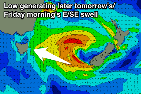
Today's increase in S'ly swell is linked to a deepening low pressure moving east across us, with the low currently stalling between us and New Zealand.
 This is resulting in a fetch of SE gales being directed at us off the tip of the South Island, with a good fun E/SE groundswell due to be generated for us later tomorrow and Friday morning.
Before this E/SE swell arrives tomorrow, easing levels of S/SE swell are due from 2ft at open beaches and 3ft+ at south facing locations.
The groundswell should then kick late to 3ft and ease from 3-4ft+ Friday morning.
Into the weekend though our secondary pulse of SE groundswell is due, from a less favourably aligned polar front projecting up towards New Zealand and then into the Tasman Sea Thursday night and Friday.
While not ideally aligned, we should see some good SE groundswell spreading out radially into us, arriving Saturday morning and kicking open beaches back to 3-4ft (smaller early).
A slow drop is then due back Sunday from 3ft or so at open beaches.
Yet another polar front tracking on a similar path to the one before but weaker should produce another smaller SE swell for Tuesday but only to 2ft+ or so, fading into Wednesday.
Coming back to the conditions due over the coming period, and tomorrow looks poor now with fresh S/SE winds, while from Friday morning offshores are due, tending variable into the afternoons.
Longer term we may see some chunky N/NE windswell developing mid-next week, but more on this Friday.

