Solid NE windswell under offshore breezes on Friday
Eastern Tasmania Surf Forecast by Guy Dixon (issued Wednesday 16th March)
Best Days: Friday morning
Recap:
Onshore breezes have been dominating today and yesterday, leading to lacklustre conditions. Unfortunately, these breezes spoiled what would've otherwise been a couple of fun 2-3ft days.
This week (Thursday 17th - Friday 18th):
A ridge has been building over the southern Tasman in the wake of a one of the most noteworthy cold fronts of the season. This ridge has been steering an easterly airflow across the Tasman which is due to gradually tend more northeasterly and eventually northerly towards the end of the week.
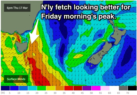
Easterly energy should fade form the 3ft range across open beaches on Thursday, before increasing from the northeast to a similar size by the late afternoon as a northerly fetch stretches across Bass Strait and intensifies.
Local northerly breezes associated with the broader system should dominate along the coast, with only the outside chance of an early offshore breeze along selected coasts.
 This northerly windswell is looking better than originally anticipated due to the longer duration and better alignment of breezes throughout Thursday and is expected to peak on Friday morning across the open beaches with peaky options in the 3-4ft+ range, dropping rapidly throughout the day.
By this stage, the southern extension of this fetch should have shifted offshore, allowing for a northwesterly breeze early, tending southwesterly thereafter.
This weekend (Saturday 19th - Sunday 20th) and next week (Monday 21st onward):
The southern and local swell windows then look to become less favourable, so the east/northeasterly swell window will take on the responsibility.
Small amounts of trade swell have been trickling in across the open beaches over the past few days but are forecast to fade throughout the weekend.
A southwesterly breeze is on the cards for early Saturday, tending southeasterly, while Sunday can expect a light southerly breeze soon blowing from the east.
From late on Monday, we should begin to see hints of fresh trade energy building as a result of an intensification in the easterly trade flow residing to the north of New Zealand after it migrated east earlier in the week.
Coupled with an easterly fetch developing along the northern flanks of a high pressure ridge, a mixture of easterly and east/northeasterly energy should provide increasing options to a peak on Tuesday in the 3-4ft range across open beaches.
Unfortunately by this stage, the local fetch steered by the ring should also be impacting the coast, leading to unfavourable easterly breezes tending northeasterly from the get go.

