Solid clean peaks for Friday morning
Eastern Tasmania Surf Forecast by Guy Dixon (issued Wednesday 4th November)
Best Days: Friday morning.
Recap:
Conditions were fairly ordinary on Tuesday with a small wind swell easing from the 2ft range under southerly breezes. Despite seeing a late kick in southerly groundswell, the quality was poor at due to this southerly flow. South facing beaches have been picking up stronger groundswell in the 2-3ft range this morning under northwesterly breezes, however conditions have deteriorated now that breezes have swung around to the east/northeast.
This week (Thursday 5th - Friday 6th):
We are still on track for a dynamic few days as the pressure gradient tightens between a strong Tasman ridge and a deep trough over mainland Australia.
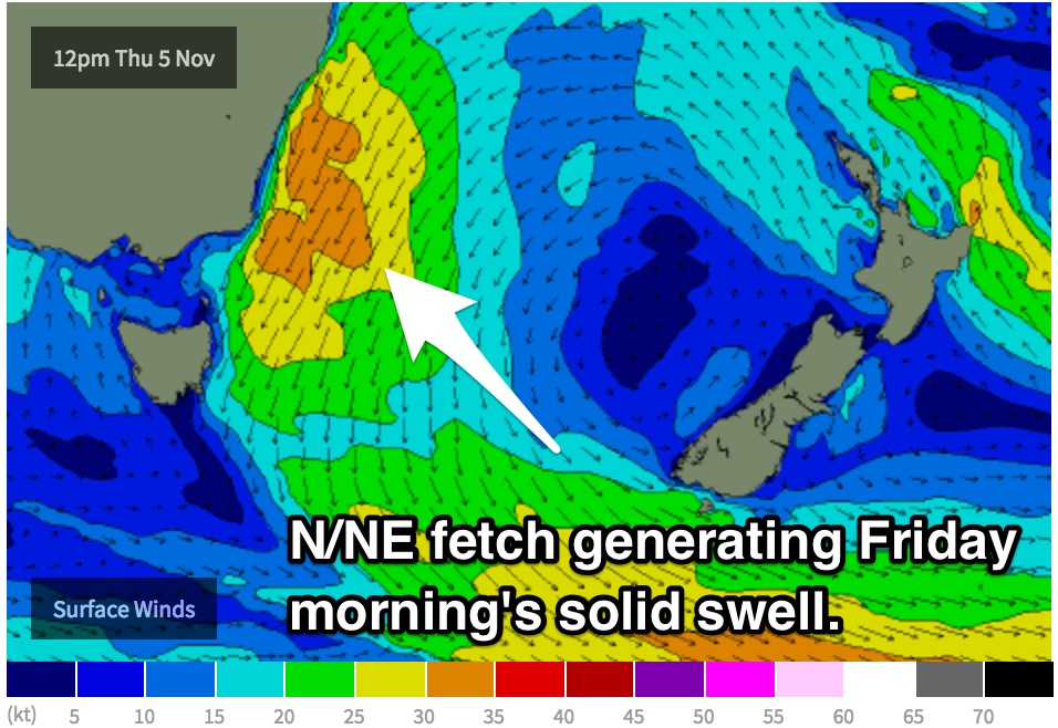
An easterly fetch which has been increasing along the coast of NSW today will tend northeasterly overnight and strengthen throughout Thursday. Strong/gale force breezes are expected to blow along the coast on Thursday whipping up a solid north/northeasterly swell due to peak late on Thursday and Friday morning.
Open beaches can expect the surf to build from the 3ft range on Thursday morning to the 4-5ft range late in the day. Unfortunately, north/northeasterly breezes associated with the swell generating fetch itself will have an impact on the quality of the surf, whipping up plenty of bump and chop.
 South facing beaches are likely to offer better options with a southerly groundswell also in the mix, providing 2ft peaks. Under these north/northeasterly breezes, these spots are likely to be offering the cleanest set ups.
Friday is looking like the best chance of a wave with the 4-6ft peaks on offer by first thing in the morning. Winds are likely to have swung offshore throughout the night giving sufficient time to iron out any bumps, cleaning up the line up.
Make the most of the early session however, because conditions will soon deteriorate as winds swing southerly from mid-late morning. If you can’t hit the early session, head to a protected southern corner for the most protection from the breeze. Here you’ll also pick up good north/northeasterly energy.
This weekend (Saturday 7th - Sunday 8th):
Saturday will offer a mix of easing northeasterly swell from the 2-3ft mark in the morning, with an element of short-range southerly energy in the water from Friday’s change.
South facing beaches are the way to go as a light southeasterly breeze continues along the coast. Make the most of the dominant northeasterly swell and hide from the winds at a protected southern corner of an open beach.
By Sunday, a lot of the energy will have dried up and we are likely to be left with 1-2ft residual background energy. On the bright side, winds look to prevail from the northwest up around St Helens and light northerly around Scamander leading to workable options, even if it is undersized.
Next week (Monday 9th onward):
The early stages of next week look fairly dormant in terms of swell generating systems.
A southeasterly fetch looks to become elongated off the southern tip of New Zealand on Saturday which may whip up a small amount of energy due Monday afternoon. We should see surf in the 1-2ft off this system, depending on the strength in coming model runs.

