NE swell this weekend, strong S'ly swell next week
Eastern Tasmania Surf Forecast by Guy Dixon (issued Friday 30th October)
Best Days: Sunday morning and Tuesday morning.
Recap:
Small southerly energy has been the main source of swell over the past few days, with south facing beaches picking up peaks in the 2ft range on the sets. As for breezes, Thursday wasnt anything special, with a light south/southeasterly flow tending easterly through the day. This morning was better, with breezes prevailing from the northwest early however it's now deteriorated with the arrival of a seabreeze.
This weekend (Saturday 31st - Sunday 1st):
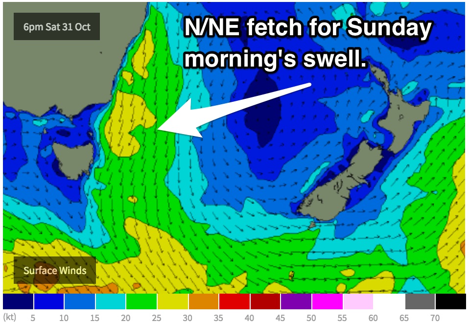
We are still on track for a north/northeasterly fetch to increase off the coast of NSW and eastern parts of Bass Strait on Saturday afternoon, increasing throughout the evening before shifting east on Sunday.
This 25-30kt fetch is likely to whip up a north/northeasterly swell building to the 2ft range late on Saturday, before peaking in the 3-4ft+ range for open beaches on Sunday morning, fading gradually in the afternoon. Meanwhile, south facing beaches will be making the most of small background southerly energy in the 1-2ft range.
 Take advantage of the morning session on Saturday as winds will be light northerly, potentially northwesterly early along the Scamander stretch. Further north however, breezes will be less favourable. St Helens is likely to be under a northeasterly breeze soon after sunrise, or at least increase soon after.
Sunday is looking much more workable, with the morning session offering northwesterly breezes dominating along the St Helens stretch, more northerly for Scamander.
Next week (Monday 2nd onward):
A southerly change will move up the coast overnight Sunday night, adding an element of short range southerly swell into the mix for Monday. This swell will gradually increase throughout the day as southerly breezes hug the coast, building into the 2-3ft range at exposed south facing beaches.
The quality of the surf is likely to be pretty ordinary, especially at south facing beaches which will offer the most size. Southerly breezes from the get go are expected to create plenty of bump and chop, limiting options to more protected beaches.
Meanwhile, the main core fetches of this system will have been working on the Southern Ocean throughout Sunday to whip up more dominant groundswell due to build on Tuesday afternoon. The latest model runs have dialled this system down a touch, however the alignment of the core fetches remains good.
South facing beaches should see the surf build into the 3-4ft range by Tuesday afternoon, holding throughout Wednesday morning, before gradually fading.
Tuesday is likely to be under a southeasterly breeze throughout the day, however light enough not to cause too many issues in the morning. Wednesday is less promising, likely to be prevailing from the northeast first thing.
Enjoy your weekend.

