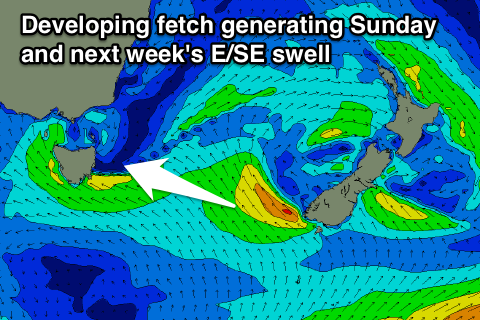
Lots of east swell to come
Eastern Tasmania Forecast by Craig Brokensha (issued Wednesday 26th August)
Best Days: Thursday morning, Friday morning, Saturday, early Sunday, early Monday
Recap
Tiny waves through yesterday and then similar tiny waves this morning ahead of an expected increase in S'ly groundswell this afternoon.
 This week and weekend (Aug 27 - 30)
This afternoon's increase in S'ly groundswell should ease back through tomorrow from 3ft across south facing beaches, while some new NE swell from an East Coast Low off the NSW coast should produce some fun peaks to 4ft across north-east swell magnets.
The NE swell should now persist through Friday and into Saturday morning as a broad fetch of strong E/NE winds continue to be aimed in our swell window through today and tomorrow morning.
A slow drop in size will be seen, back from 3ft to possibly 4ft Friday morning, down from 2ft Saturday morning.
Winds will be favourable and light from the SW tending SE Thursday and then fresh SW tending S'ly Friday, bringing with it an afternoon increase in S'ly swell which will then ease Saturday from 2-3ft under W'ly winds.
From later Saturday we're still expected to see building levels of E/SE swell from a strengthening and broadening fetch of E/SE winds through the entrance to the southern Tasman Sea.
This should kick up a building short-range E/SE swell through Sunday to 4-5ft later in the day, easing from a similar size Monday morning, back further from 3-4ft Tuesday morning.
Winds are due to be workable Sunday and Monday mornings before onshore E/SE winds develop and then persist through Tuesday and possibly Wednesday.
Later in the week a final pulse of E/NE swell may be seen from a fetch of E/NE winds off New Zealand through next week, but with the models still diverging on the fetch in the southern Tasman Sea, we'll have to review this on Friday.

