Plenty of swell to come but with deteriorating winds
Eastern Tasmania Forecast by Craig Brokensha (issued Monday 24th August)
Best Days: Wednesday afternoon, Thursday morning, Friday morning
Recap
Tiny mix of swells Saturday with dicey winds, and then a small NE windswell to 1-2ft Sunday with morning offshores ahead of a S'ly change.
This change kicked up a weak windswell this morning but to no real decent size.
This week and weekend (Aug 22 - 30)
The swell should become tiny to flat through tomorrow and remain so into Wednesday morning ahead of a good afternoon kick in new S'ly groundswell.
This is being generated by a vigorous and elongated polar frontal progression south of the state today and tomorrow.
This groundswell should build to a solid 3-4ft across south facing beaches before easing from the 3ft range Thursday morning.
Also in the mix should be building levels of NE swell from a deepening and stationary surface trough off the Southern NSW coast.
This trough is forecast to produce a fetch of strong to gale-force E'ly extending to the central Tasman Sea and falling just within our swell window.
The trough will remain just on the edge of our swell window through Tuesday and Wednesday before weakening but aiming a better aligned fetch of E/NE winds towards us through Thursday.
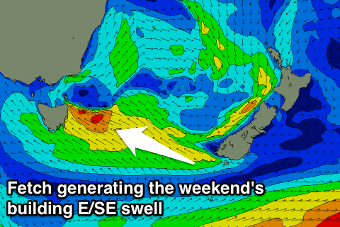
Into Friday this E/NE fetch will disappear, while a polar front pushing up from the south will merge with the remnants of the trough in the Tasman Sea, resulting in a developing and strengthening fetch of E/SE winds directly east of us through the day strengthening further into the weekend.
 What this will all result in is a vey active period with NE swell in the 4ft range Thursday, easing into Friday ahead of some building E'ly swell during Saturday to the 6ft range, and further to 6-8ft Sunday afternoon. A slow drop in size is then due from Monday as the fetch through the southern Tasman starts to ease.
Looking at conditions and a NW tending N/NE breeze will favour south facing beaches picking up the S'ly groundswell Wednesday, with a morning W'ly offshore Thursday morning with the mix of swells.
From Friday conditions will become dicey with a SW tending fresh SE breeze, persisting from the E/SE Saturday and Sunday, tending more E/NE Monday and Tuesday. Winds aren't due to relent until about Tuesday, but we'll have another look at this on Wednesday.

