Good week of southerly swell
Eastern Tasmania Forecast by Craig Brokensha (issued Monday 17th August)
Best Days: Every day until Sunday
Recap
Flat conditions and nothing to really surf over the weekend with tiny surf continuing today.
This week (Aug 18 - 21)
As touched on last week, this week is looking really fun with plenty of S'ly swell on the way.
A strong low pushing across us today is projecting a fetch of weakening S/SW gales through our swell window, with a fresh S'ly swell due into tomorrow.
South facing beaches should peak tomorrow morning to a solid 3-4ft+ with improving W/SW tending W'ly winds.
With the low moving off to the east tomorrow, the swell will drop significantly into Wednesday, fading from 2ft to maybe 3ft at south swell magnets, with a possible late increase in new S'ly swell, due Thursday. Winds will remain favourable with a W'ly tending variable breeze.
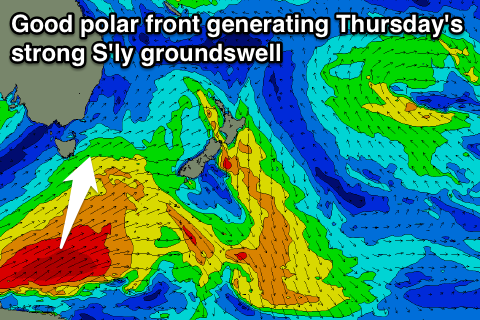
Our pulse of S'ly groundswell due Thursday is still on track and has actually been upgraded in size.
 A vigorous and favourably aligned polar frontal system will develop south-southwest of the state and project a fetch of gale to severe-gale SW winds up through our southern swell window towards the Tasman Sea.
A strong S'ly groundswell will result, peaking Thursday to a good 4-5ft across south swell magnets, easing slowly into Friday from 3-4ft, further down into the weekend.
Conditions will be excellent at these south facing breaks with a NW tending N/NE breeze Thursday and then strengthen N/NW winds Friday, possibly kicking up some small NE windswell.
Into the weekend and beyond there's nothing significant on the cards with some new S'ly swell possible into early the following week. More on this Wednesday though.

