Fading SE swell, S'ly swell mid-next week
Eastern Tasmania Forecast by Craig Brokensha (issued Friday 6th June)
Best Days: Dawn Saturday, later Tuesday, Wednesday, Thursday
Recap
Strong SE groundswell pulse yesterday to 3-4ft+ with offshore winds and pumping waves across most of the coast.
The swell dropped back to the 2-3ft range today as favourable conditions continued.
 This weekend and next week (Jun 6 - 12)
The recent SE swell event is expected to dry up into the weekend, with the low generating it over near New Zealand pushing east and out of our swell window.
Open beaches may still see the odd 2ft set before becoming tiny to flat Sunday. Winds will remain good and offshore though from the WNW, so aim for a dawny tomorrow.
Next week is real tricky with the southerly swell pulse timings.
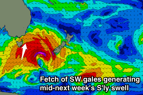
A vigorous low moving across us on Monday will likely be too west in nature initially to generating any decent S'ly swell for the morning Tuesday, but a trailing fetch of SW gales should produce a short-lived pulse through the afternoon to 3ft at swell magnets (tiny elswhere).
This swell will drop into Wednesday though from 2-3ft.
Of greater importance is a fetch of S/SW gales generating at polar latitudes on the backside of the system through Tuesday night, generating a good S'ly groundswell pulse for Thursday afternoon. Another 3ft swell is likely before fading through Friday.
Longer term a good S/SW groundswell is on the cards for next weekend as a strong and deepening polar low fires up to our south on Friday, but more on this in the next update. Have a great weekend!

