Fun SE swell to end the week
Eastern Tasmania Forecast by Craig Brokensha (issued Wednesday 27th May)
Best Days: Thursday, Friday, Saturday morning, Tuesday morning
Recap
Continued action across the coast with pulses of S/SE groundswell and favourable winds. A low point in swell energy was seen this morning, but a new SE groundswell should have been seen into this afternoon.
This week and weekend (May 28 - 31)
Into the end of the week, we've got good but inconsistent pulses of SE groundswell from a stalling low pressure system south of New Zealand through the start of this week. A fetch of storm-force SE winds wrapping around its southern flank has generated some long-range but strong SE groundswell that should of started to show this afternoon, with a peak due tomorrow morning to an infrequent 3ft+ across south-east swell magnets.
A slight drop is likely into the afternoon, ahead of one final pulse Friday morning to the 2-3ft+ range. This should then ease back into the afternoon and further from 2ft or so Saturday morning.
Winds will favour swell magnets with fresh to strong NW winds tomorrow, and W/NW winds Friday and Saturday. Come Sunday winds will tend from the W to SW but the swell will be non-existent, bar a possible late increase in S'ly swell.
 Next Monday onwards (Jun 1 onwards)
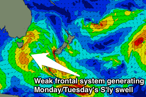
We've got some good S'ly swell due into early next week, as a relatively weak but broad polar front projects up from below the state, past our coast on Sunday afternoon/evening.
A fetch of strong S/SW winds should produce a new S'ly swell for Monday afternoon, reaching 3-4ft across south facing beaches, before easing from a similar size Tuesday morning.
Winds will be terrible though and fresh from the SW tending S/SW Monday and then a more workable W/SW tending S/SW Tuesday.
Into the second half of the week, we may see the frontal system responsible for Monday/Tuesday's swell become part of a broad stalling low off New Zealand's South Island, producing a SE swell for us, but we'll have to review this on Friday.

