Southerly swells with windows of clean conditions
Eastern Tasmania Forecast by Craig Brokensha (issued Wednesday 20th May)
Best Days: Friday morning, Saturday morningm Wednesday morning
Recap
Tiny surf yesterday and this morning, with some better groundswell due over the period.
 This week and weekend (May 21 - 24)
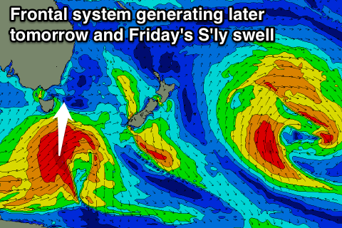
A small and weak S'ly windswell tomorrow is expected to be reaplced by a much stronger and late increase in S'ly groundswell.
This has been and is continuing to be generated by a vigorous polar low that's to our south, with the swell kicking real late in the day to 3-4ft+ across south swell magnets but with poor and onshore S/SE winds.
Friday will see the S'ly groundswell easing from a similar size and with offshore W'ly winds through the morning, so this is the day to surf.
Into the weekend the swell will continue to ease out of the south from 2ft+ across south swell magnets with morning offshores again.
We may see the S'ly groundswell lingering around 1-2ft into Sunday morning as weaker polar frontal activity continues, but it'll be generally small and slow.
Next week onwards (May 25 onwards)
One final pulse of sneaky S/SE groundswell is due Tuesday afternoon and Wednesday, on the backside of all the strong frontal activity pushing over towards New Zealand.
During the weekend, a fetch of severe-gale to storm-force S/SE winds are due to be generated at polar latitudes to the south of New Zealand.
An inconsistent but long-period S/SE groundswell should result, kicking later Tuesday to 2ft at south swell magnets before peaking Wednesday to 3ft under offshore N/NW winds.
Longer term there's nothing major on the cards, but more on this Friday.

