Southerly swell this week, north-east swell from the weekend
Eastern Tasmania Forecast by Craig Brokensha (issued Monday 27th April)
Best Days: South swell magnets from Wednesday, open beaches from the weekend
Recap
A fun E'ly swell through Saturday but with average S/SE winds, favouring southern corners.
Sunday was much better with a slight kick in size and light winds for most of the day creating generally clean conditions.
Today the E'ly swell was on the ease with a new S'ly swell in the mix with clean 2-3ft waves across open beaches.
 This week (Apr 28 – May 1)
This week will be dominated by S'ly swell as a series of weak but favourably tracking cold fronts push up past our coast and through the Tasman Sea.
A pulse this afternoon should ease back from 2-3ft tomorrow morning across south swell magnets, with a new better pulse through Wednesday, kicking to 3ft again through the day and then a third final pulse Thursday to 3ft+.
Winds will improve over the coming days with a W/SW tending SE breeze tomorrow, W/NW tending E'ly winds Wednesday and NW tending variable breezes Thursday.
The swell should ease through Friday from the 2ft+ range across south swell magnets under NW tending fresh N/NE winds.
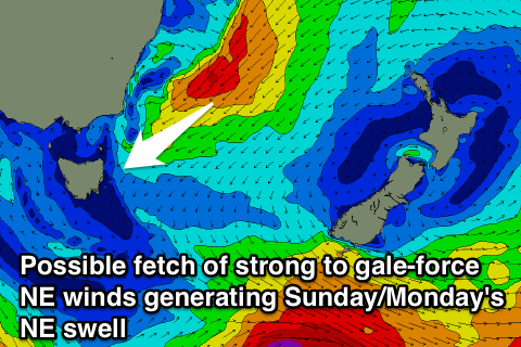
Into this weekend we're looking at a really good NE groundswell event, touched on in last Friday's update.
Another possible East Coast Low is forecast to develop off the NSW coast and drift south from Friday through the weekend while projecting a fetch of strong to gale-force NE winds down towards us.
This should produce a moderate to large sized NE swell that's likely to build slowly Saturday before kicking stronger Sunday, peaking overnight and then easing Monday.
The models are still a touch divergent on the southward movement and intensity of this system though, so we'll have to have a closer look on Wednesday.

