Great run of easterly swell
Eastern Tasmania Forecast by Craig Brokensha (issued Wednesday 22nd April)
Best Days: Thursday morning, Friday, Saturday morning, Sunday, Monday morning
Recap
The S'ly swell continued to hold in through yesterday morning at a decent size, above expectations while today was tiny as expected but a strong new E'ly swell should of shown across open beaches this afternoon from the bottom of the intense East Coast Low sitting off the Southern NSW Coast.
 This week and weekend (Apr 23 - 26)
The swell for tomorrow is still on track, but local winds are now looking dicey, Friday looks great.
A fetch of strong to gale-force E/SE winds were generated in our eastern swell window, with a weaker fetch still being aimed towards us.
The low will unfortunately drift south, maintaining a fetch of E/SE winds in our swell window through tomorrow but this will also bring onshore SE winds to the coast. There's a a chance for a variable breeze at dawn but check the local winds observations for this.
Size wise, the swell should be in the 3-5ft range most of the day, easing back to 3-4t Friday.
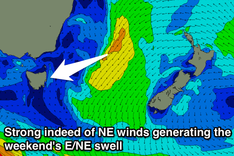
Late Friday a new E/NE swell is due to fill in, generated by an infeed of strong NE winds on the eastern flank of the weakening East Coast Low.
This swell should come in at a good 3-4ft on Saturday and Sunday morning before slowly easing into the afternoon and then down from 2-3ft Monday morning. There is the chance for the odd bigger one during the peak of the swell, but you can mainly expect surf in the 3-4ft range.
Winds are due to improve Friday with a light variable breeze, likely tending offshore through the morning before a late offshore W/NW'ly kicks in.
Saturday should then see early fresh W/SW winds ahead of an afternoon S/SE change and then fresh SW tending variable winds on Sunday.
Into next week the E/NE swell looks as if it will be replaced by building levels of S'ly swell as a broad Tasman Low develops, but we'll have a closer look at this on Friday. In the meantime, enjoy the current E'ly swell event.

