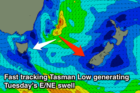
Fun tomorrow morning, new E/NE swell Monday afternoon/Tuesday
Eastern Tasmania Forecast by Craig Brokensha (issued Friday 3rd April)
Best Days: Saturday morning, Monday and Tuesday in southern corners
Recap
Tiny waves yesterday morning ahead of a strong and large kick in S'y swell through the afternoon with strong to gale-force S-S/SW winds.
Today was much cleaner as the low started to drift south-east cleaning up an easing 3-4ft of SE swell across open beaches, with bigger sets across south swell magnets. Sea breezes are now creating bumpy conditions across most breaks.
 This weekend and next week (Apr 4 - 10)
The low responsible for yesterday's and today's SE swell has moved off to the east and with this we'll continue to see the swell drop away through tomorrow from a small and inconsistent 2ft to maybe 3ft across south swell magnets, becoming tiny into the afternoon.
Into Sunday there isn't expected to be any major size left with a small NE windswell not due to offer any significant push above 1-2ft. Winds will be light offshore tomorrow morning ahead of NE sea breezes and then N/NW to N/NE Sunday.
Come Monday the NE windswell is due to fade to northing, and a new better E/NE swell on the cards for Tuesday is now looking to arrive Monday afternoon.
This swell is due to be generated from a Tasman Low developing off the Southern NSW Coast, but it's quick south-east track now looks worrying.
We should still see some form of E/NE swell through Monday afternoon and Tuesday but size wise it only looks to be in the 2-3ft range across north-east facing beaches. A small weak S'ly windswell is also due in the wake of a S'ly change Monday, persisting Tuesday.
The outlook into the middle to end of next week is still divergent with the possibility of a strong low forming off the Southern NSW Coast and vigorous front pushing up past us delivering a S'ly groundswell. More on this Monday though. Have a happy and safe Easter!

