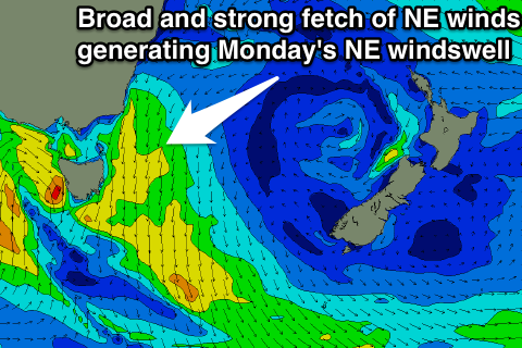
Improving NE windswell Monday afternoon
Eastern Tasmania Forecast by Craig Brokensha (issued Friday 20th March)
Best Days: Monday afternoon and evening, early Tuesday at north-east swell magnets, Wednesday morning south swell magnets
Recap
Easing levels of NE windswell and long-range E/NE groundswell yesterday from the 2ft+ range with tiny surf left into this morning.
 This week and weekend (Mar 21 - 27)
A S'ly change overnight may produce a tiny and weak increase in S'ly swell tomorrow to 1-2ft max across south swell magnets and winds should be workable and light offshore before sea breezes kick in.
Into Sunday and Monday some better NE windswell is on the cards with a fetch of strengthening NE winds developing down the western Tasman Sea.
North-east facing beaches should build to 2ft through the afternoon, with the odd bigger set on dark, while Monday will provide the most size to 3-4ft across north-east facing beaches as the swell peaks through the day.
Winds are due to improve during the day, swinging from a morning N'ly around to the N/NW and W/NW late, so a mid-late afternoon surf is the best time to get out.
Once the offshore change moves through the swell will start to ease with Tuesday only expected to offer 2ft+ waves early, tiny later.
A strong S'ly change though should bring with it a fresh pulse of S'ly swell through the afternoon, reaching 3ft+ across south swell magnets into the afternoon. Winds will be poor though and fresh from the SW tending SE.
The swell will ease through Wednesday rapidly from 2ft or so across south facing beaches but with offshore W/NW winds.
Longer term there's still nothing major on the cards besides windswell from fronts and troughs pushing across us.

