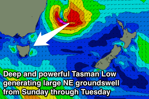
Building swell from Friday, large from the NE from Sunday arvo
Eastern Tasmania Forecast by Craig Brokensha (issued Wednesday 18th February)
Best Days: Friday morning, Saturday morning, Sunday morning northern corners, Monday, Tuesday, Wednesday morning
Recap
The surf has tailed away the last couple of days, bottoming out this morning. Not to worry there's a ton of swell on the way.
 This week and next week (Feb 19 - 26)
Tomorrow morning is expected to start out tiny again but a mix of small NE windswell and possibly the first signs of long-range NE trade-swell is due to show later in the day with 2ft sets at north-east facing beaches but this will be with onshore NE winds in any case.
Into Friday the mix of small NE windswell and long-range NE trade-swell from the established fetch of E'ly winds in the Northern Tasman Sea should come in at 2ft to occasionally 3ft as early offshore winds give way into a gusty SE change around midday.
From Saturday we're expected to see wave heights climb slowly as a tropical low which may reach a Cat 1 cyclone before crossing the Queensland coast drifts down the East Coast tomorrow and Friday, dipping the fetch of E'ly trades more down towards us and into our swell window.
With this we're expected to see more NE swell impacting our coast, and a further intensification of the low off the Southern NSW coast should see a fetch of gale to severe-gale NE winds aimed at us over the weekend, generating a couple of larger pulses of NE groundswell from Sunday through Tuesday.
The dynamics around this low are still moving around but we're likely to see the NE trade-swell coming in at an inconsistent 3-4ft Saturday before building to a larger 4-5ft+ Sunday afternoon and coming in around the 6ft range Monday and Tuesday.
There's even a scenario where the low continues to be aimed favourably towards us through Sunday resulting in larger 6-8ft waves later Monday/early Tuesday but we'll have to review this Friday.
Winds in general will be variable Saturday morning ahead of fresh N/NE'lys, with N/NW tending N/NE winds Sunday and then NW winds Monday morning ahead of a gusty S/SE change through the afternoon and SW winds Tuesday morning. Check back here Friday for a much clearer idea on the timing, sizes and local winds revolving around next weekend NE groundswell though.

