Easing east swells
Eastern Tasmania Forecast by Craig Brokensha (issued Monday 1st September)
Best Days: Tuesday protected southern corners, Wednesday morning, Thursday morning
Recap
The weekend provided great waves across selected northern corners with a large and powerful E/NE groundswell filling in through Saturday before peaking and then dropping back a touch in intensity Sunday.
This morning the swell was back to a smaller 3-4ft, but conditions great with all day offshores.
This week (Sep 1 - 5)
Tomorrow will be interesting as we see the E/NE swell slowly drop away, mixed in with a similar sized short-range S'ly swell.
The E/NE swell will fade as a result of the strong Tasman Low generating it weakening right back through yesterday, while the S'ly swell will be generated as a deepening surface trough and subsequent low projects a fetch of strong to gale-force S'ly winds up past us.
Both swells should be in the 3-4ft range tomorrow morning before easing into the afternoon and further from 2ft at open beaches Wednesday and 2ft+ at south swell magnets.
Winds will be best for protected southern corners tomorrow with a fresh S/SW tending S'ly breeze, while Wednesday should see W/SW tending SE winds.
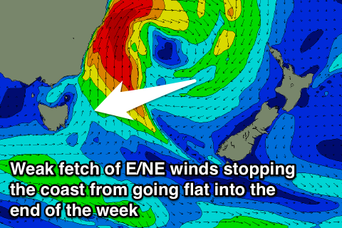
 There's nothing significant on the cards for the rest of the week with small levels of E/NE swell off the south-eastern flank of the deepening low in the Tasman Sea expected to stop the coast going flat. Open beaches should pick up 1ft to occasional 2ft sets right through until Saturday.
Longer term the outlook is a little undecided with model divergence regarding the positioning of a surface trough off the East Coast. So with this we'll review the outlook again Wednesday.

