Great Friday, fading through weekend
Eastern Tasmania Forecast by Craig Brokensha (issued Wednesday 6th July)
Best Days: Midday Thursday onwards, Friday, early Saturday, Monday onwards in protected spots
Recap
Yesterday started out slow but a fresh pulse of S'ly groundswell should of shown into the afternoon and with winds swinging W/NW there would have been some fun waves around. This swell dropped through today with easing 2ft waves across south swell magnets.
This week and Saturday (Aug 7 - 9)
Tomorrow's pulse of short-range S'ly swell is looking a little better now, with a vigorous front pushing up past us this evening kicking up 2-3ft of S'ly swell across south facing beaches through the morning. This will ease through the day though as winds swing from the W/SW to a light W/NWly.
Friday is looking much better with the strong S'ly groundswell due being upgraded slightly.
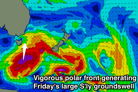
 This swell is currently being generated by a vigorous polar front south-southwest of the state, with a broad and elongated fetch of severe-gale to storm-force SW winds expected to be projected up towards New Zealand and through our southern swell window.
A large long-period S'ly groundswell will result, filling in Friday and peaking through the middle of the day. Exposed south facing breaks should see 6ft sets, but open beaches should also reach 3-4ft. Conditions are looking great with moderate NW winds.
The swell will start to ease Friday afternoon and more noticeably overnight leaving much smaller and fading 2ft+ sets Saturday morning under stronger W/NW winds.
This Sunday onwards (Aug 10 onwards)
Another strong but nowhere near as powerful polar front is expected to push up past us Sunday afternoon and this should kick up a late increase in new S'ly swell that will peak through Monday. Winds won't be as favourable though with strong SW tending S'ly winds and 4-5ft of swell at south swell magnets. Tuesday will continue to see plenty of size but winds don't look to improve until the swell really starts to drop away. More on this Friday.

