Friday for SE swell, fun E'ly swell for early next week

Eastern Tasmania Forecast by Craig Brokensha (issued Wednesday 2nd July)
Best Days: Friday, Saturday morning, Monday morning, Tuesday in protected northern corners
Recap
Wave heights dipped back temporarily yesterday morning, but a fresh pulse of S'ly swell should of kicked into the afternoon.
Today the swell backed off again and we'll see a further drop in size through tomorrow, so I hope you made the most of it.
This week onwards (Jul 3 onwards)
Today's S'ly swell should ease back through tomorrow, but into Friday a fun pulse of SE groundswell is expected, generated by a strong polar low to the south of New Zealand today.
This swell should come in at an inconsistent 2ft to maybe 3ft across open beaches under fresh but easing W/NW winds.
The swell should then drop away into Saturday from an inconsistent 2ft. A small increase in S'ly swell may be seen through the day, but this probably won't be larger than the easing SE groundswell.
As we move into Sunday a weakening mid-latitude low is expected to move across us and into the Tasman Sea.
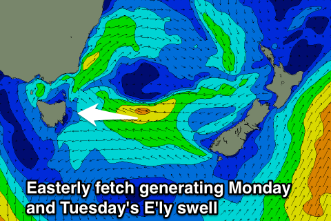 This should see a fetch of strong E'ly winds aimed towards us during the day, kicking up an afternoon increase in E'ly swell to 2ft across open beaches. More size is due into Monday though as the stationary fetch of E'ly winds continue through Sunday evening and Monday before swinging NE and out of our swell window into Tuesday.
Open beaches should build to 3ft+ Monday afternoon and then ease from 3ft or so on Tuesday.
Winds should be nice Monday and light offshore ahead of an afternoon NE'ly, with Tuesday seeing less favourable fresh N/NW winds down the coast.
Longer term there's nothing too major on the cards besides small levels of S'ly swell, but we'll review this again Friday.
Comments
Craig... I take it you'll be UP dating this? ;) Sounds like Mickf is enjoying the biltong lol
Indeed I will, looks like a great week coming up for you guys!
Glad the SE swell pushed through today.
Yeah..... West of NZ looks interesting next week to say the least (tues)...... Cheers....
East of NZ looks pretty damn good also....AGAIN!!!!
Geez yeah strong NE fetch of that high, I know where I would be going :)
East of NZ or East Coast of NZ? The East Coast of looks bloody wet and windy all of next week. I reckon southern NSW is gonna do pretty well (latest forecast is up now for Sydney et al).
Further south Ben on the East coast
SI NZ SE Coast nooks and crannys Don?
Forecast has just been updated: www.swellnet.com/reports/forecaster-notes/eastern-tasmania/2014/07/04/ac...
Nice work, craig....
Welly.... East coast Tassie has some pretty insane setups
Ah yes, the ol' single hPa trick to make a MSLP chart look sexier!
Yeah thats what I thought Ben,
That site always looks more lines...? So thats due the the ol' singular hPa trick..?
More increments. I see now.
Sexy stuff :)
Yeah, we use 2hPa spacings which seems to be most common. 4hPa is sometimes used but it doesn't pick up small features very well. However it's often a better fit for when drawing in fronts and trough (ie this BOM chart).
Was just looking at your WAMS then, I tend like SN's WAMS more, as that other site, gets me too excited, for nothing :) BOM look boring IMO, but as you say pick up the occluded troughs and fronts etc.
All good Ben, Cheers