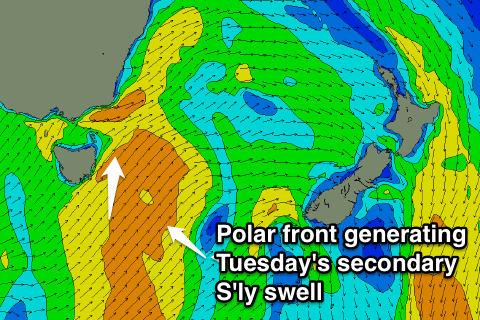
Southerly swell dominates the period
Eastern Tasmania Forecast by Craig Brokensha (issued Friday 27th June)
Best Days: Monday morning, Tuesday morning, Wednesday morning, early Thursday south swell magnets
Recap
There's been no surf to see across the coast with flat conditions and stiff offshores.
This weekend onwards (Jun 28 onwards)
Tomorrow should remain flat, although there's a slim chance that a broad fetch of strong to gale-force N/NW winds may kick up a small N/NE windswell across exposed beaches.
Of greater importance is a strong mid-latitude front passing across us on Sunday, projecting a fetch of strong to gale-force S/SW winds up past our coast.
This should kick up a short-range S'ly swell through the late afternoon to 3-4ft at south facing beaches but with strong SW winds.
A peak in size is expected on Monday morning with solid 4-5ft sets expected across south swell magnets, with 2-3ft waves at open beaches.
Fresh and gusty W'ly winds will favour more open beaches than south swell magnets before swinging more SW through the day.
 A renewal of S'ly swell energy is expected through Tuesday as a secondary broader polar front pushes up from below us and past out coast again Monday afternoon and evening.
This should keep south facing beaches topped up with 4ft sets as winds remain fresh and gusty from the W/SW.
The frontal activity will die down into Tuesday evening and a gradual drop in size is due as winds swing more to the W/NW.
Longer term there's nothing too major on the cards so make the most of the coming S'ly swells. Have a great weekend!

