Easing surf ahead of a rare S'ly swell and funky winds
Java, Bali, Lombok, Sumbawa forecast by Craig Brokensha (issued Tuesday 5th July)
Best Days: Wednesday, Thursday morning, Friday afternoon through Sunday, Monday onwards
This week and next (Jul 6 - 15)
A new swell was seen across the region over the weekend, backing off in size through Sunday and Monday ahead of a new inconsistent S/SW groundswell today. Exposed breaks should be offering 6-8ft sets, smaller inside the Bukit with variable morning winds ahead of moderate to fresh E/SE trades.
A drop in size is expected this afternoon, dropping further through tomorrow from 6ft on the sets at swell magnets, continuing into Thursday, bottoming out Friday morning.
 Into Friday afternoon a small and very inconsistent increase in S/SW groundswell is due, produced by an unfavourably aligned and distant fetch of severe-gale W/NW winds in the Heard Island region.
This swell should build through Friday to an inconsistent 3-5ft at swell magnets, steadying Saturday. Our models have Saturday showing more size but this seems to be incorrect. Instead we'll probably see the surf hanging between 3-5ft at swell magnets all weekend ahead of a new large swell Monday.
This swell will be quite funky and from a straight S'ly direction.
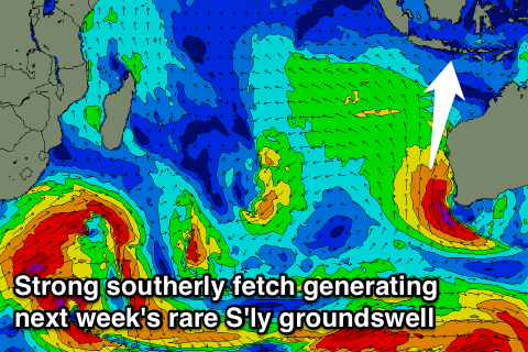
A relatively weak polar front projecting towards WA will form into a deep cut-off low immediately off Margaret River.
With this we'll see a fetch of gale to severe-gale S'ly winds produced off the southern WA coastline, aimed squarely at Java. With the system developing quite high in latitude we'll see a consistent but acutely angled S'ly swell generated (possibly showing later Sunday) building through Monday and easing Tuesday.
South swell magnets are expected to build to 8-10ft through the afternoon Monday, with less size towards Lombok and Sumbawa as they fall in the swell shadow of Western Australia.
 Tuesday should then see the swell easing back from the 8ft+ range but Java will see a secondary pulse of reinforcing S/SE swell from the stalling fetch.
Variable winds are forecast to develop along with rain due to an active monsoon trough across the region, so think outside the square.
Longer term a moderate S/SW groundswell is due Thursday but a better SW groundswell is on the cards for the following weekend. More on this Thursday.
16 day Bali Forecast Graph
16 day East Java Forecast Graph
16 day Sumbawa Forecast Graph


Comments
WTF monsoon trough in the middle of the dry season???? Been in bali for a week &
winds have been cross shore most days! What is goin on?Plenty of swell about but huge tides & cross shores have been making for a hard time finding any classic Indo waves!
I'm over here as well ulus got pretty good yesterday 6ft plus but today about 3ft
and the winds are almost onshore. Its quite strange winds at the moment and
well the forecast looks pretty lame.
It rained every day except 2 for the 3 weeks I was in Bali/Java in June.
Very odd hey
And the mozzies at g land were outta control
Here looks to be the reason, look at those warm SST's off Java and Eastern Indonesia..
Craig, do you have any comments about post -big el nino events. Seem to recall reading that following the last couple of big el ninos there was a strong la nina event. Although this won't be related to a la nina, it might be the hangover from the el nino. Was a very dry summer for most of Indo last year.
There is some indication that they bounce back to La Nina, but this is not always the case. Current indications have it heading that way..
And re the S'ly swell, it's looking a touch smaller and weaker, mid-period S'ly swell. Developments late in the forecast period are worth keeping an eye on :o
Great summary here Craig & co . How to score with a 190 degree sth swell in jawa