Slower period continues, a touch more active from later next week
Java, Bali, Lombok, Sumbawa forecast by Craig Brokensha (issued Thursday 23rd July)
Best Days: Exposed spots over the coming period each morning
This week and next week (Jul 24 – 31)
A new S/SW swell should be building across the region this afternoon, but with no major strength or power, with it being a mid-period number.
A peak in size is due tomorrow to 6ft+ across exposed breaks, before easing later in the day and further into Saturday and then Sunday morning.
Moderate to fresh E/SE trades are due through the coming period, lighter and more variable for a few hours through the morning, favouring the exposed spots picking up the most size.
Sunday afternoon's longer period but less consistent pulse of S/SW groundswell is still on track with the strong polar front generating it, projecting a healthy fetch of S/SW gales through our southern swell window the last day or two.
 This swell should pulse to an inconsistent 4-5ft+ across exposed breaks through the afternoon, and then ease into Monday.
Tuesday's swell looks the best with a stronger polar low generating a fetch of W/SW tending SW gales through our southern swell window, producing an inconsistent but good S/SW groundswell. This should peak Tuesday afternoon to an infrequent 4-6ft across exposed breaks, easing into Wednesday and becoming small to tiny through Thursday.
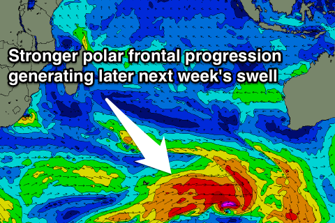
Later in the week, a new inconsistent and better S/SW groundswell is due across the region, generated by a broad, strong and multi-staged polar frontal system moving in from the west. This should produce a longer-lived moderate to large swell event.
The first pulse is due to build Friday, with a secondary pulse keeping wave heights up Saturday, easing slowly into Sunday.
Size wise, we're probably looking at exposed spots peaking in the 6ft to occasionally 8ft range. We'll confirm this on Tuesday though.
16 day Bali Forecast Graph
16 day East Java Forecast Graph
16 day Sumbawa Forecast Graph

