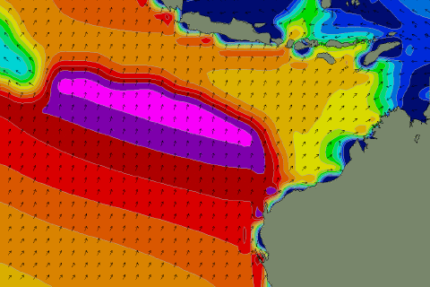
Large, strong but inconsistent S/SW swell for the weekend
 Java, Bali, Lombok, Sumbawa forecast by Craig Brokensha (issued Thursday 28th May)
Best Days: Every day over the coming period, experienced surfers only Saturday and Sunday
This week and next week (May 22 - 29)
Some new S/SW swell has offered more size across exposed spots the last couple of days and this is due to ease back into tomorrow morning from 4-5ft across swell magnets.
A late increase in new S/SW swell is due tomorrow though, and this should keep 4-5ft sets hitting exposed spots late in the day before easing into Saturday morning.
There's been no change to the large and powerful S/SW groundswell due Saturday across the region, with the swell pushing into Western Australia this morning, providing large 10-12ft waves around Margaret River.
A peak is due into the afternoon/evening to a very inconsistent but strong 6-8ft with 10ft bombs, easing from 6-8ft+ early Sunday morning, further down into Monday and Tuesday.
Weak trades through tomorrow are expected to freshen into the weekend and then ease a touch through next week as the swell slowly bottoms out into Tuesday and Wednesday.
The next noticeable increase in swell is due to build slowly through Thursday and peak Friday, that being a very inconsistent long-range SW groundswell generated south-east of South Africa and Madagascar last night and today.
A fetch of severe-gale to storm-force winds are being aimed towards us, but the system will weaken and dip unfavourably to the south-east tomorrow morning, leaving a moderate sized but inconsistent SW groundswell for our region.
Exposed breaks around Bali should build slowly Thursday to 5-6ft by dark, holding a similar size into Friday.
Some more consistent S/SW swell is due to take its place into Friday afternoon and the following weekend, but we'll have a closer look at this next Tuesday.
16 day Bali Forecast Graph
16 day East Java Forecast Graph
16 day Sumbawa Forecast Graph


Comments
Got reports from mates who surfed Ulu's this morning that it was only 2ft with the occasional bigger set. That's a fair way down on the 4-5ft forecast?
I've pointed this out before in the notes, but exposed breaks are ones more around the south side of the Bukit.
I wouldn't have expected 4-5ft at Ulus.
But I have noticed this S/SW swell due through Wednesday and Thursday didn't really perform in any case and then this may have lingered into today. Hopefully the S/SW groundswell tomorrow and Sunday comes in good.
So you're saying Ulu's isn't an exposed break in SW groundswells?
You may wish to amend your forecast page then.
http://www.swellnet.com/reports/indonesia/bali/uluwatu/forecast
Yeah it does seem to go a little large on these smaller swells. I use the forecast there as a good guide for exposed breaks.
This swell was S/SW, I'd say W/SW hits straight on.
When its a sth swell g.land can be twice the size of ulus . Ulu may not favour that direction & has not much to offer meanwhile g.land is going off with south swell forming into a peak called launching pad . Typical scenario . Got ya back craig . & that was a very sth swell .
Hey Craig
Not sure you will have the numbers available nor the time to give a shit but what was the primary swell size and direction for the June30/31. I'm interested in East Java. Also roughly where did the storm form that generated it? I wasn't watch for this run.
Cheers
You mean May 30/31?
yeah sorry.
Here it is, ps how big did it get and was it biggest Saturday evening?
Here's the raw model output, with some things pointed out.
Dawn Saturday saw the swell out of the S/SW at 1.5m @ 19.4s
The swell built through the day strongly, reaching 2.4m @17.4s dy dark.
Now Sunday morning shows more size, but this is because it's combined that easing 12s swell in the first column with the new long-period S/SW groundswell overnight.
So instead of that 2.7m @ 16.0s dawn Sunday (which is bigger than Saturday evening) I would of expected it to be more around 2.3m @16s.
So possibly similar size swell late Saturday/early Sunday if all went to plan?
Oh and it was generated by a very strong low forming south of Heard Island and then projected up towards the south of WA...
https://www.swellnet.com/reports/forecaster-notes/bali-sumbawa-east-java/2015/05/26/good-period-swell-large-over-weekend
You're a legend!!
Photos indicate it was 6-8ft late sat. Saturday being pretty raw early but by dark a mate reckon it was epic "as good as it gets" but I think he may have been a touch excited! And Sunday was on to, cleaner but a touch smaller through the day. I'm not sure about early morning..... I'll ask.
Thanks ay.
Awesome, sounds bang on expectations!