When hot and cold collide
 In the atmosphere, the most powerful weather systems are created when pressure/temperature differences are at their greatest.
Tropical cyclones for example become super-charged if travelling over a warmer than average ocean, feeding off the additional energy available from the sea. A classic example of this is shown here when Severe Tropical Cyclone Yasi strengthened towards the Queensland coast in 2011 while travelling over warmer than normal temperatures.
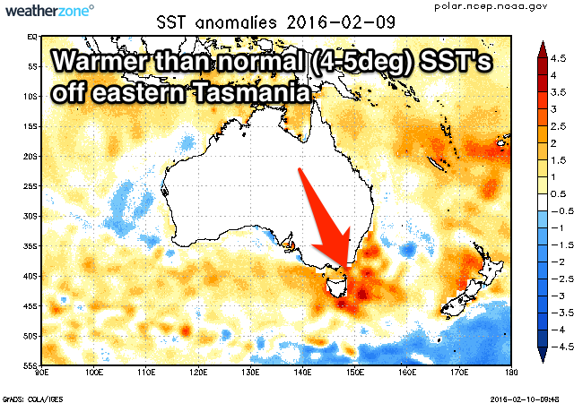
Currently off the east coast of Tasmania, sea surface temperatures are 4-5 degrees above average (above right), the result of a warm core Eddy shedding from a strong southerly burst of the East Australian Current.
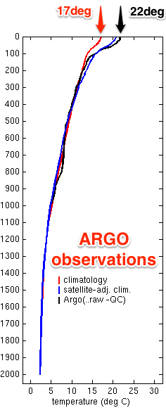
 Observations from an ARGO float (left) off the Tasmania coast on the 2nd of February show that sea surface temperatures down to 100m were near 22 degrees (black line), while the climatological average is closer to 17 (red line).
This warm water contributed to the flooding seen across the north-east of Tasmania a couple of weeks ago, as a stationary trough drew in moisture from the warm seas onto the coast.
Heading into early next week a cold front will be steered up and across the south-east of the country under the influence of the Long Wave Trough.
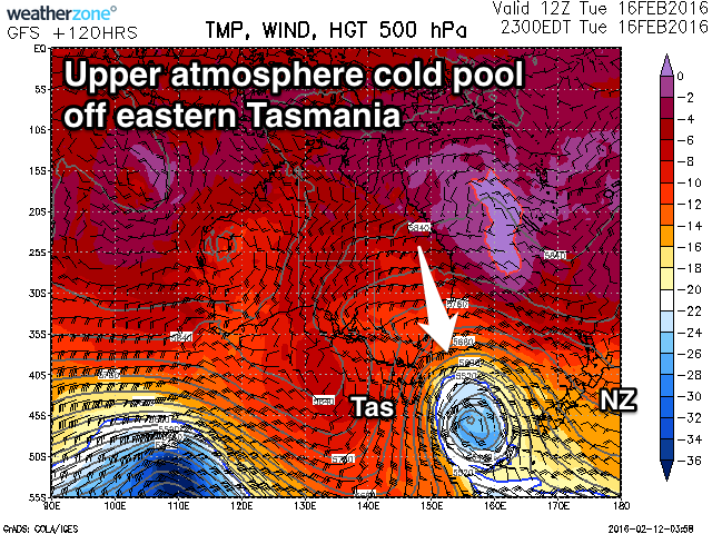
A cold pool of air in the upper atmosphere (bottom) is forecast to shed off from the cold outbreak, moving over the aforementioned area of warm water resulting in the intensification of a deep and powerful low pressure system in the southern Tasman Sea as it feeds off this warm energy source.

Without the warmer than average waters a much weaker low or trough may have formed, but instead, the southern NSW and eastern Tasmanian coast is set to receive a prolonged episode of moderate to large southeast groundswell through the latter parts of next week.
Late summer and autumn is the time to expect these systems as cold air outbreaks increase in strength and frequency yet the East Australian Current continues to feed warm water from the Coral Sea.
Keep an eye on the East Coast forecasts for updates on the expected sizes and timing of next week's swell episode.
Images courtesy of Weatherzone and IMOS


Comments
Thanks Craig.
Yeah, been keeping my eye on that one. Although it can change a bit as we get closer, I would have said this will be sending some serious swell to more than just the southern nsw and tasmanian coast.
Cheers BF, and yeah the structure is still moving around a bit, but it's not the best system for any of those Western Pacific Islands if that's where you were thinking?
Western Pacific Islands, beautiful. :-)
No, will be at work for most of the swell anyway, but the wife and kids are away over a long long weekend coming up, so I will be visiting certain western pacific islands over the weekend of March 11 to 14, regardless of conditions. Can't pass up a free pass like that.
Will be in touch closer to the time to see if you might be heading nearby also.
are we gunna get dodgey winds too or just heaps of good bazzas?
Winds decent at this stage through Thursday morning but swell looks more south than east at this stage..
I'm sure we'll have something cooking around home