Fiji Pro: Forecast

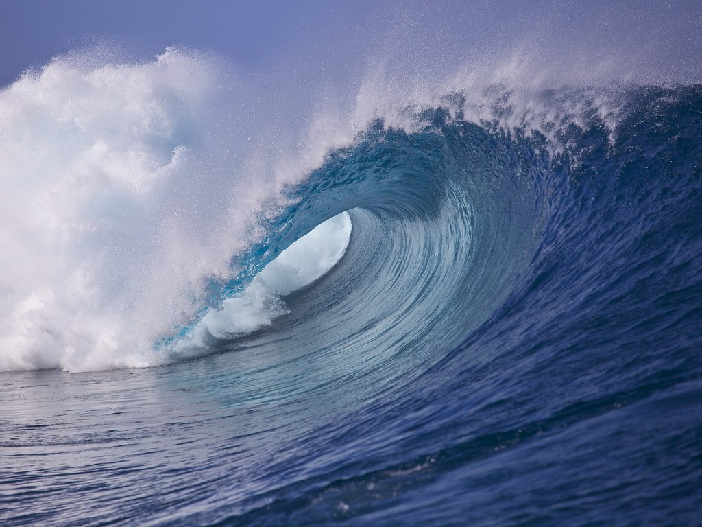 Hot off the heels of a large pumping swell yesterday afternoon, stronger southeast winds have relegated everyone to Restaurants today as the swell peaked. This has provided a good warm up for the coming Men's event as there's some big swell on the cards for the Fiji Pro.
So what exactly can we expect?
A broad and near stationary low in the Tasman Sea has delivered pumping swells all week to the Australian East Coast, and this filtered in yesterday afternoon across Fiji, peaking today.
This swell is expected to taper off tomorrow and further into the start of the waiting period on Sunday, but a couple of reinforcing pulses will provide plenty of surf for the first couple of days.
Sunday should see clean, easing 4-6ft waves with light to moderate E/SE trades, becoming smaller into Monday and dropping from 3-5ft under lighter more variable winds.
A slow period is due from Tuesday through Thursday with inconsistent long-range energy to 2-3ft+ at Cloudbreak (with 4ft sets through Thursday). These will likely be called lay days.
Into the end of next week and the following weekend, a couple of large long-period S/SW groundswell pulses are due.

The source of these swells will be a broad and vigorous low pressure system pushing across Tasmania and through the southern Tasman Sea early next week, projecting a fetch of severe-gale W/SW winds through Fiji's swell window. The track of this system isn't ideal but the sheer scope and strength should see a large long-period S/SW groundswell generated, building through Friday and reaching 6-8ft across Cloudbreak during the afternoon with 10ft bombs more than likely into the evening.
A drop in swell should then be seen into Saturday from 6-8ft+, but this will be softened by a secondary pulse of large S/SW groundswell through the afternoon. A more pronounced easing trend is then due from the 6ft range Sunday, further into Monday.
The trades are expected to strengthen from the SE through Friday and the following weekend, throwing open the opportunity for the event organisers to switch over to Restaurants.
Longer term there's indications of one final long-period S/SW groundswell in the 6-8ft range around the Tuesday/Wednesday 16/17th but we'll provide further updates on this in the ongoing commentary below.
All in all the forecast is good with plenty of surf days on the cards for the Fiji Pro waiting period, and it'll be up to the organisers to pick the eyes out of it. //CRAIG BROKENSHA
For a run down on the Men's form and Harro's picks for the coming event, click here.
Comments
So how come they didn't run today?
As per the WSL Press Release:
“There are good waves out there today,” Kieren Perrow, WSL Commissioner, said. “Unfortunately we have a high tide at 9:30 and a predicted onshore wind with the swell dying all day. Being day one of the window we're going to be off for the day and come back tomorrow morning. We're still looking at a really good swell for the end of this week and we're excited about what's to come.”
Ok thanks Ben.
The swell due later in the week and into the weekend has been downgraded a touch with the frontal system pushing into the southern Tasman Sea not due to perform as well as it was forecast late last week.
Still we're looking at numerous pulses in the 6-8ft range from later Friday through early the following week with favourable winds.
Tracking possible Strong SW for June 12-14. Surfline allocated this storm #purplebloboftheweek
12 hours ago
The #PurpleBlobOfTheWeek is located in the Southern Ocean under Australia, and now making its way into the Tasman Sea. Generated from a strong complex winter storm that has been slowly tracking eastward under the Land Down Under, the bulk of this blob is currently slamming South Oz and Tasmania with large surf, with New Zealand next at bat. This swell will then make it’s way up through the Tasman Sea toward New Caledonia and eventually Fiji, which is good news for the patiently waiting pro men of the WSL. Arrival time for this swell in Fiji will be on Friday and the weekend (12th-14th) local time.
They should be keeping a closer eye on this better blob more in the swell window the end of this week.
This will generate a larger S/SW groundswell for Monday afternoon (15th) to 6-8ft with bigger bombs likely, easing from a similar size Tuesday morning (16th).
shit close enough, they claimed that southerly swell for Snapper.
Actually they have downgraded though its now a medium-strong swell.
Whatever happens one thing we know is that wsl will get it all wrong - , they always do - another nail in the coffin. And when's it going to be pay-to-view?
Surfline not calling for much more than 5-6ft for this first swell.
Face height or surfers height?
Our surfers height. So no more than double overhead.
Whatever happens one view we know is that Swellnet will get it all wrong - they always do - another nail in the coffin. And when are you going to going to pay to view?
Bob shove a tampon in it
Agreed.
I think these swells have all been pretty severely over-called. Especially this first pulse.
First few pulses were downgraded since the article, mentioned in the Punters Club article.
"The swell due into Friday afternoon and Saturday has been downgraded a touch but we’re still looking at easy 6ft sets with the odd bigger one in the mix Saturday and Sunday morning.
We’ve also got an upgrade in the swell due to arrive Monday, peaking overnight and easing Tuesday. This swell looks to be more in the 6-8ft range with the possibility for some rare bigger bombs before easing into the rest of the waiting period."
Here's my latest thoughts..
Today’s building S/SW groundswell should be reinforced by stronger S/SW groundswell pulses through the weekend, coming in around 6ft on the sets with rare bigger bombs possible at times.
Of greater importance is a much larger and stronger S/SW groundswell due to build through Monday afternoon, easing Tuesday and further through the rest of the waiting period. Cloudbreak should build to an easy 6-8ft, with bigger bombs possible towards the evening Monday, before easing from 6-8ft Tuesday morning.
Conditions should be workable each day with strengthening SE trades through tomorrow, easing back into Sunday and Monday while tending more S/SE each afternoon.
I think they were idiots running this morning in 3 feet surf on a forecast like what you outline above.
Please tell me the latest GFS forecast for Fiji is completely wrong!!!
Please tell me the LWT will stall in the Tasman for the whole waiting period?
I can't bare to watch another small wave shitty WSL event after Brazil
Bit scary, isn't it....
I know it's a long way out but the 2nd half of the waiting period for the men looks pretty decent to me. From say the 11th onwards.
1st 4 days....knock the comp off....looks insanely dismal after that.
Edit, although towards the end of the waiting period some light at the end of the tunnel is showing (for some reason I thought this comp finished on 11 June??)....but goes to 17th June. So perhaps they hope and pray that something comes at the end of the waiting period.
Yeah the 11th looks the next chance for any sort of Tasman action, in the right direction. Plus or minus a day of model error, plus a couple of days swell travel time, it's looking pretty marginal.
Kolohe is $51 to win. Small swell mmmmmmmm not a bad roughie