Swell early in the new year

I look forward to the footage of you again then Steve!!
As for options, fair to say that Nth NSW has much more options than SE Qld in these conditions and every man and his dog will be flocking to the SE Qld locations. Bugger that, they can have it. Whole East coast, including Tassie looks set to light up next week if that GFS model comes to fruition!!!
Look forward to your forecast today boys.
The way things are shaping up for next week, this will be one of those swell events that gets talked about for years to come. The thing that is most surprising is that all the models agree about this deep tasman low. However the EC has it slipping away over NZ before wednesday while access and GFS have it continuing to lurk in the mid Tasman.
This is what I want to see from a La Nina!!

Yeah, except this isn't a Tasman low. This is a tropical low drifted southwards from the South Pac into the Tasman.
Much like July 2001 and Wati.

Hey Barstardos!
Here's hoping some of that info you shared with me recently gets put to use. If this sucker comes off I'll give you a bell.
However the EC has it slipping away over NZ before wednesday while access and GFS have it continuing to lurk in the mid Tasman.
By: "barstardos1"
Are you referring to the long range charts here B? EC and GFS to some extent has this thing retrograding SW towards the coast this coming weekend. Both models then indicate it to decay as it heads eastwards towards NZ early next week.

NOGAPS and CMC have it slipping behind NZ.
Be good to see tonights updates :)
I'm yet to find a reason to take CMC seriously.
I think it's the worst model I've ever seen.
Looks like it might make TC status.
Wati redux anyone?
Looks like it might make TC status.
By: "freeride76"
You mean before Wed/Thurs Steve?
Not sure when Don or even if.
Differing opinions between Vanautu met, Fiji Met and JTWC.
If it keeps moving westerly (broadly speaking) then it will come under very favourable uppers.
I keep getting Wati flashbacks.
Don and Steve - being in Sydney my froth horizon for this swell is further back than you in Qld and FNC. Although the system is likely to spin up to something impressive and push in to your swell window before Wednesday - it wont be until the weekend at the earliest that us sydney surfers can hope for groundswell joy from this thing. So yes, I am looking at how it is modelled to behave from sunday until mid next week. Yes i am having Wati flashbacks too.
Stu, hoping it comes together!
Sose was the other one that formed in that broad area near Vanautu before moving into the Coral Sea.
That swell produced clean 12-15ft surf for one glorious day; still the biggest paddle surf I've been out in on the East coast.
Not comparing, just saying.
Was that when Wayne Deane paddled the outer bank at Snapper? Know the session I mean?
Not exactly sure but probably.
The tow-ins at Currumbin got most of the photos from that day.
Maybe if I angle my lens towards the Great Dividing Range and someone holds a mirror up top I could get a few lineup shots...
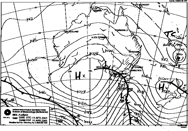
It was Cyclone Sose Steve. Wednesday, April 11, 2001.
Wayne Deane paddled outside Snapper. Made it out through D'Bah apparently. Can't find photos of that but will keep looking. Here's Margo getting towed at Currumbin from Tracks of June that year.
Oh, fuck I'm getting excited...
Thats the one Stu.
July 2001 got all the accolades but that Sose swell was just mind-blowing.
So big and perfect.
fuck me ,how good is this weekend going to be if the wind drops right back
Don and Steve - being in Sydney my froth horizon for this swell is further back than you in Qld and FNC. Although the system is likely to spin up to something impressive and push in to your swell window before Wednesday - it wont be until the weekend at the earliest that us sydney surfers can hope for groundswell joy from this thing. So yes, I am looking at how it is modelled to behave from sunday until mid next week. Yes i am having Wati flashbacks too.
Stu, hoping it comes together!
By: "barstardos1"
B, I'm not frothin over this oversized tradewind swell stuff. I'm frothin over the good meaty, powerful E'ly groundswell, so for me it's happening around the same time it hits you anyway (Sunday/Monday).
And if you ask me, Monday looks like it could go down as one of those all time days, with light winds and SOLID E'ly groundswell on the cards!!!
Hmmmm, I notice that GFS has pushed out the timing of the peak of the swell from this system.....not a good sign at all.
Also, am I missing something here? By my calculations based on the 00z GFS run, I've got the peak of the E'ly groundswell arriving on Monday with peak swell periods in the 14-15sec class and significant swell heights around the 3.5m mark. Models aren't showing this so either they're missing something or my hand calcs are way out?
Steve et al, you got any calcs?
The model data I'm looking at for the 00z run shows that the strongest part of this swell will arrive during the early hours of Sunday morning on the Goldy and during the mid-morning down in Sydney.
The periods associated with this swell episode is around 12-13 seconds, but embedded within this are a couple of 13-14 second pulses that are hard to see hitting the Goldy, but push in down Sydney overnight Sunday. So I'm guessing a late increase in size on the Goldy.
The swell will hold all Monday and then back off gradually into Tuesday.
I don't particularly look at the associated swell heights as these can be lost in the mix with the closer-range swell.
Both models seem to now have brought forward the arrival of this swell as the cradling Tasman high now moves eastwards quicker before the TC deepens and pushes S/SWwards.
To quote Stu - "Fuck i'm excited".
Looks like it will do a Wati and slide toward NZ sending solid East groundswell before settling over NZ pumping out SE lines.
The only thing i love more than epic E groundswell is epic SE groundswell.
now if only we had the banks we had last April
Becoming more likely by the minute that TC Vania will be born.
Wati and Sose and Rewa, Bola and Esau all epic cyclones formed in the Fijian AOR.
Will Vania join that illustrious list?
Fair to say that I'm a little dissappointed that the models have shifted the cradling high. Don't get me wrong, it's still gonna generate some nice lines, but fair to say latest GFS has severely downgraded the maximum swell heights from this forecast system now.
And B, as far as I can see the system get's whisked away rather quickly to the SE and it's only a small compact fetch by then so I can't see a great deal of size from the SE from this system once it get's whisked away to the SE. What are you seeing?
Why disappointed Don?
I thought you were railing against a big E swell?
I would say we'll see some revision yet, especially if this storm becomes a cyclone.
Track is uncertain and a more straight W movement before recurvature can't be ruled out.
No doesn't looks as good to me for down here either, looking at GFS.
EC is a little better, but in either case there will be solid amounts of swell pushing in across the East Coast.
stop flogging the dead horse idiots. the "early new year" came and went, the swell you predicted did not happen.
"TC or not TC" was a joke and this latest TC speculation is even worse.
Donweather, I nominate you for idiot of the year. Please get off the internet.
^^^ Ha ha ha...rock on Brian!
Why disappointed Don?
I thought you were railing against a big E swell?
I would say we'll see some revision yet, especially if this storm becomes a cyclone.
Track is uncertain and a more straight W movement before recurvature can't be ruled out.
By: "freeride76"
Yesterday's GFS runs were pointing at a damn solid swell to hit the east coast. This morning this has been severely downgraded, hence my dissappointment. Yeah sure, we've still got some solid swell, just not as BIG as was forecast yesterday.
And a W'ly track Steve will mean even less of a cradle against the Tasman high, reducing the fetch size. Only thing going for a W'ly track is intensification of the compact fetch working on an already active sea state and swell being generated closer to home.
Will have to wait and see I guess. I see JWTC are still the least excited by this tropical depression and probably the most experience in my view.
Finally JWTC now getting excited by this system!!!
Finally JWTC now getting excited by this system!!!
By: "donweather"
Nice to see you're cutting back the detail in you laughable forecast attempts. Keep up the good work !!!
The current Coral Sea action had me strolling down memory lane. Here's what I found...
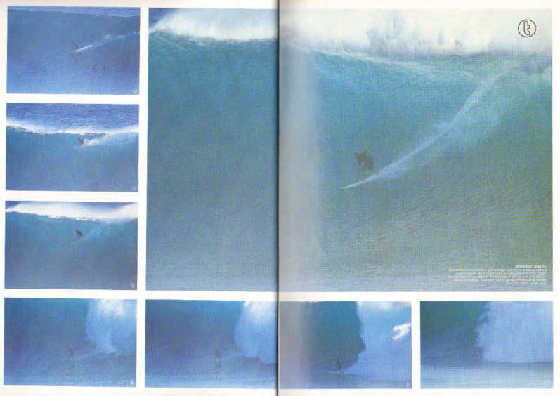
TC Sose, April 2001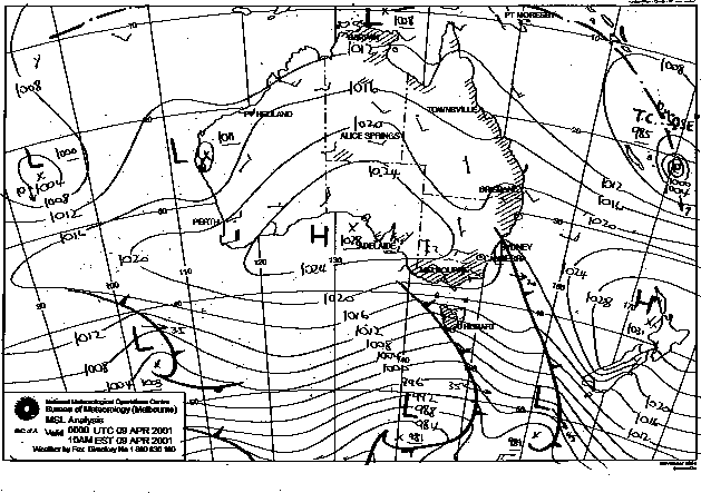
The July 2001 swell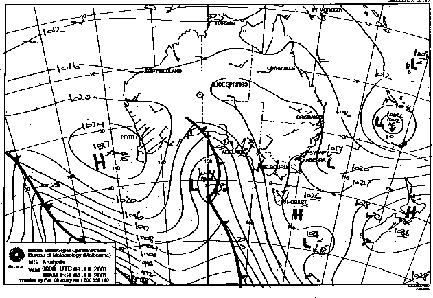
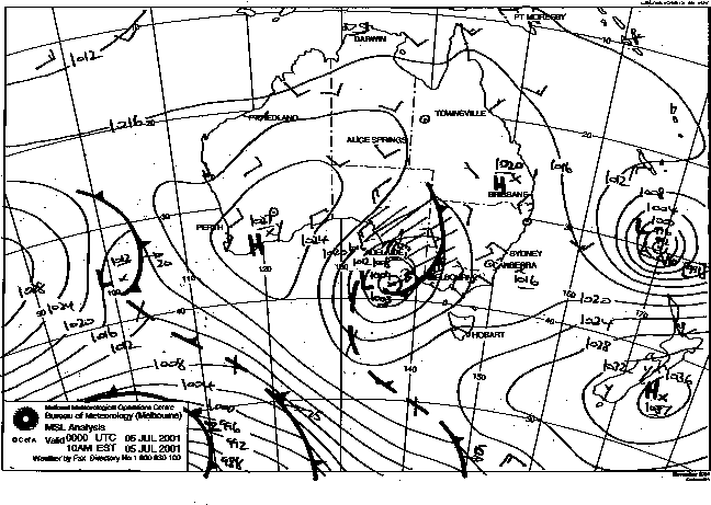
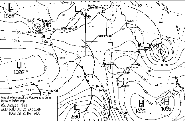
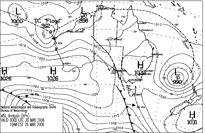
TC Wati, March 2006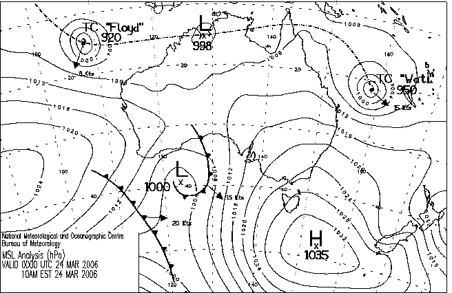
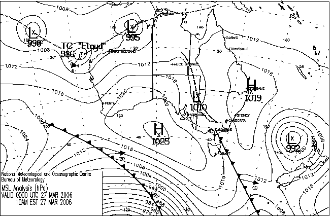
Pretty tough comparing this new system to WATI Stu, but bloody nice to see some sweet looking onion rings nonetheless.
Yeah, Wati is the benchmark system, eh Don? Lovely speed and track. Beautiful...
Wati was just way closer to the mainland Stu. Got down to 988hPa as it went extra-tropical off the SE Qld coast, 900km east of Cape Moreton!!!
And yet of the three systems Sose, with it's weak supporting high, produced the biggest surf.
I hear ya Steve :) and the Sose synoptic charts above look bloody damn close to the forecast charts for this weekend too!!!
Actually just went through the swell archives and bugger me Sose, including pre-Sose is almost a mirror image of what's currently forecast. Started off with sizey tradewind swell (10ft @ 10 secs) almost exactly as we've got now, and then ramped up to a peak around 12ft @ 12 secs.....not too dissimilar to what is forecast for this coming weekend.
A large Tasman high looked to fill in after this peak in swell, masking the archive swell heights with large local SE wind swell contamination.

There were a couple of different swell events from Wati Don.. an initial E/NE swell in SE Qld/NNSW as Wati tracked parallel to the Qld coast (I recall shooting 8ft+ peaks from North Burleigh headland.. got the pics somewhere), however the really impressive stuff was a huge E'ly swell for central/southern NSW that reached 10-12ft+, originating from Wati's extra-tropical expansion off the west coast of NZ's North Island a few days later. SE Qld received a secondary SE swell in the 6ft+ range from this source, if I recall correctly.
This latter swell source was further away (for southern NSW) that Wati's initial track off the southern Qld coast, but the fetch was phenomenal (in strength and coverage) which resulted in the significantly larger waves heights for Sydney.
OK, I'm a little confused. Most models and met bureaus have this system moving SWwards however JWTC are indicating SEwards (at least in the short term)?
MODEL GUIDANCE INDICATES A PASSING MIDLATITUDE TROUGH WILL WEAKEN THE SUBTROPICAL RIDGE POLEWARD OF THE SYSTEM, ALLOWING IT TO MOVE TO THE SOUTHEAST AND UNDER THE UPPER-LEVEL RIDGE AXIS. THIS WILL REDUCE THE VERTICAL WIND SHEAR AND THE SYSTEM WILL LIKELY DEVELOP BETWEEN TAU 12 AND 24.
Edit: Whoops, my bad, just realised I read the JWTC incorrect. The above is for the tropical system to the west of Aus!!! :)
JTWC have upgraded the system to TC status but as yet unnamed.
This is starting to look really juicy.
If this thing stays slow moving as it tracks inside Grand Terre then all kinds of hell could break loose.
This is starting to look really juicy.
By: "freeride76"
Uh huh, I'm hearing ya Steve. EC has an even better looking fetch aimed at SE Qld/ Nth NSW too!!!
If this thing stays slow moving as it tracks inside Grand Terre then all kinds of hell could break loose.
By: "freeride76"
I'm still hoping EC comes off as GFS looks like it could have some of the fetch dissected at least in the early stages of development.
Been enjoying this chat guys, this system looks like it's kicking into gear now on the sat pics....
Some info from the BOM site for others that are interested;
GALE WARNING 193
THIS AFFECTS OCEAN AREA: SUBTROPIC
AT 111800UTC
IN AN AREA BOUNDED BY 25S 175E 27S 168E 25S 162E 25S 175E: EASTERLY
35KT AT TIMES.
GALE AREA SLOW MOVING.
GALE WARNING 013 ISSUED FROM RSMC NADI Jan 11/1922 UTC 2011 UTC.
************CORRECTION TO CENTRAL PRESSURE***********
TROPICAL DEPRESSION 03F CENTRE [990HPA] WAS ANALYSED NEAR 19.1S 169.4E AT
111800UTC. DEPRESSION SLOW MOVING.
CLOCKWISE WINDS 30 TO 35 KNOTS WITHIN 080 TO 240 NAUTICAL MILES AWAY FROM THE
CENTRE IN SECTORS FROM NORTH THROUGH EAST TO SOUTHWEST.
AREA OF GALE SLOW MOVING.
Keep up the good work guys... :)
Yep, that precursor area of gales to the south has been active for the last 36-48hrs.
The head of that fetch now extends to 500nm of the sunny coast.
TC Vania in the house.
Lets make her feel welcome.
She's more than welcome Stu, just so long as she stays offshore.
My money is still on a secondary SOLID peak come late Sunday/early Monday in SE Qld.
Been off line for a week. Have enjoyed reading back through this chat, even I-U-Brawn's (not the messiah, just a naughty boy) interjections.
After all that rain in SE qld, I wonder what the beaches will look like after this episode is over.
Have to say that I'm filled with anticipation, even given the fact that I will have to watch some of this from the sidelines when it really kicks in.
Howling nor-easter atm (still!), wonder when that will break up for central coast, which is where I am now. Predicted light northerly winds somewhere down the track will light up a batch of breaks here.
Latest EC charts are progging something rather interesting in the Coral Sea early next week!!
How's this for blatant scare mongering!!
Just saw a report on channel 9 that showed the weather guy referring to the +384hr forecast..
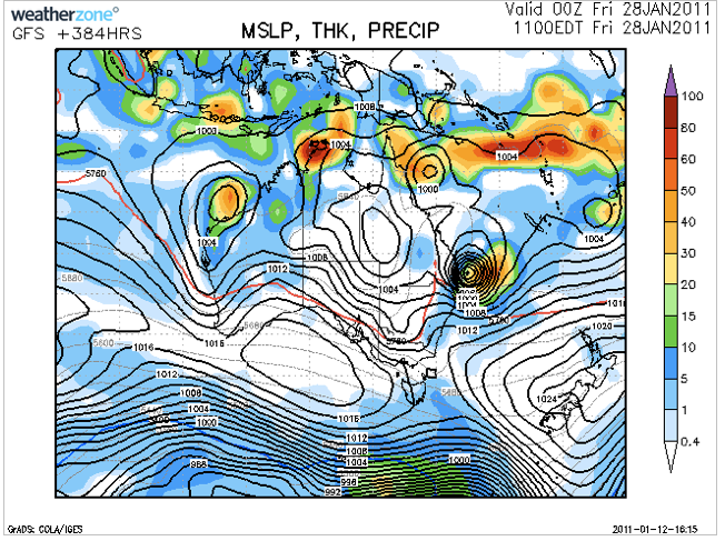
Yes that's right the +384hr forecast and saying there is a 30% chance of this occurring.
So to scare Brisbane people further and make a story they have shown a cyclone crossing the region in 2 weeks time.
What a joke!
Has anyone seen the latest run on the BOM 10 day models. Suggests a pretty nice scenario of low in the coral sea cradled against a big high - sending a spray of swell across the entire east coast for a week. It wont be big - but it will be rideable and consistent - something we havnt seen in a long time.
http://data.theweather.com.au/access/imageserver.jsp?image=grads/access-...
Have a look at the surface wind - looks great to me
http://data.theweather.com.au/access/imageserver.jsp?image=grads/access-...
The ECMWF broadly agrees with the scenario but has the low dipping toward NZ much faster
This is a major upgrade on anything we have seen in months. Looks like the Goldy and North coast will get the best of it, with the swell finally making it down to Sydney by late in the first week of 2011. Also suggests that a long tradewind fetch behind it may set up a swell train that could last for weeks