Fun period of swell with strong winds

Western Australian forecast by Craig Brokensha (issued Wednesday April 2nd)
Best Days: Today, tomorrow, Saturday in the South West, Monday, Tuesday morning in the South Wesrt
Features of the Forecast (tl;dr)
- Mod-large mid-period SW swell building today with a less consistent SW groundswell for tomorrow AM, easing
- Strong E/SE winds tomorrow AM, tending SE into the PM
- Smaller Fri with strong E/SE winds
- Small-mod S/SW groundswell for later Fri and Sat AM, easing with strong E/SE tending SE winds
- Smaller Sun with strong E/SE tending SE winds
- Moderate sized S/SW groundswell for later Sun, peaking Mon with mod-fresh E/SE-E winds
- Easing swell Tue with similar winds
- New larger SW groundswell due later next week
Recap
There was nothing of note through yesterday, while today our new mid-period SW swell is on the build, starting slow in the South West but now 5-6ft on the sets with clean conditions.
We should see the swell reaching 6-8ft into this afternoon as winds strengthen from the S/SE with 2-3ft sets possible on dark across Mandurah, 2ft+ in Perth.

Building swell this AM
This week and weekend (Apr 3 - 6)
Today's increase in mid-period swell will be followed by a similar sized but less consistent SW groundswell tomorrow morning, easing through the day. Both swells were generated by the same healthy frontal system projecting towards us earlier in the week, with the storm tracking slightly ahead of the groundswell, resulting in the mid-period increase in swell today.

The South West should ease back from 6ft to occasionally 8ft with 2ft to possibly 3ft sets in Mandurah and 2ft waves across Perth with a strong, easing E/SE-E wind, shifting SE into the afternoon.
The downwards trend will continue through Friday with stronger E/SE winds due to blow all day thanks to low pressure trough deepening just offshore of the coast.
This will dominate our winds through the weekend before it slowly breaks down into early next week.
Strong E/SE tending SE winds are due on both Saturday and Sunday, while swell wise, some small background S/SW swell is expected on the former, produced by a strong but easterly located polar frontal progression that’s currently south of the state today.
This swell might show later Friday with Saturday morning revealing the peak to 4-5ft or so in the South West with tiny waves to the north.
This swell will ease into Sunday while later in the day but more so Monday, a better S/SW groundswell is due, produced by a better, broader polar frontal progression forming south-southwest of us through Friday and Saturday.
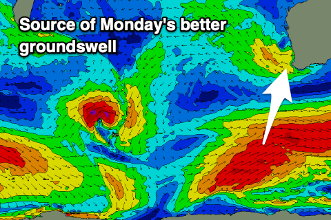
A good fetch of gale to severe-gale SW winds will be generated through our southern swell window, with the groundswell expected to build later Sunday to 4-5ft in the South West, peaking Monday to 6ft with small 2ft waves in Mandurah and 1ft ti possibly 2ft sets across Perth.
A great, moderate to fresh E/SE-E offshore is due with this swell on Monday, with similar winds on Tuesday as it eases.
As touched on in Monday’s notes, the longer term outlook is more active as a series of strengthening polar frontal systems fire up to the south-east of South Africa, moving east while generating fetches of severe-gale to possibly storm-force W-W/NW winds.
A series of large groundswells are due, likely building Thursday but showing more so through Friday next week with favourable E/SE-SE winds. More on this Friday.