Windy week of building surf

Western Australian forecast by Craig Brokensha (issued Monday March 31st)
Best Days: Wednesday, Thursday, Friday in the South West, Saturday and Monday in the South West
Features of the Forecast (tl;dr)
- Small S/SW groundswell tomorrow with pre-dawn E winds tending S'ly around or shortly after dawn
- Mod-large mid-period SW swell building Wed with strong E/SE-SE tending S/SE winds
- Less consistent SW groundswell for early Thu, easing
- Strong E/SE winds Thu AM, easing ahead of strong S/SE sea breezes
- Smaller Fri with strong E/SE winds
- Small-mod S/SW groundswell Sat AM, easing with strong E/SE winds
- Smaller Sun with strong E/SE winds
- Moderate sized S/SW groundswell next Mon with NE tending NW winds
Recap
The weekend was generally small with not much to work with except for a few waves on the South West magnets.
Today the swell has remained small with a slow 2-3ft wave across Margs.
This week and weekend (Apr 1 - 6)
Into tomorrow, we’ve got a slightly flukey S/SW groundswell due across the South West, generated by a strong but poorly aligned and late forming fetch of W/NW gales to our south on the weekend.
The groundswell will impact selected south magnets and should come in at 4ft with tiny waves to the north, easing into the afternoon. Unfortunately a weak trough looks to arrive just after dawn with early variable E winds due to shift S/SE which isn’t ideal for those south magnets.
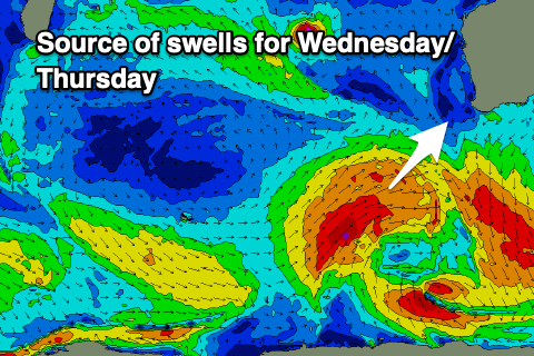
Of greater importance is the SW swell due into Wednesday/Thursday with mid-period energy due to build through the former, peaking later with some stronger groundswell due into the latter.
The source of the mix of swells is a strong polar frontal progression that’s currently projecting towards us (upgraded from last week), with various fetches of gales due to produce a moderate to large sized swell. The mid-period energy for Wednesday should build to 6-8ft in the South West later, 2ft to possibly 3ft Mandurah and 2ft+ Perth, easing from 6ft to possibly 8ft early Thursday in the South West, 2ft to occasionally 3ft Mandurah and 2ft+ Perth.
Local winds on Wednesday look strong but E/SE-SE through the morning, tending S/SE into the afternoon with Thursday seeing great, strong E/SE offshores, easing ahead of strong S/SE sea breezes.

Friday will be clean but windy all day with strong, persistent E/SE winds and smaller surf.
Later in the day but more so Saturday morning, some small reinforcing S/SW energy is due, produced by a trailing front behind the system currently projecting towards us, with a fun 4-5ft+ wave due in the South West, 1-1.5ft to the north under strong, persistent E/SE winds.
Longer term, more S/SW swell energy is due into Monday as a strong but easterly located Southern Ocean frontal progression fires up in our southern swell window. This will generate side-band energy as winds go more NE, favouring those south magnets. Following this, the polar storm track south-east of South Africa looks to fire up early next week, bringing some decent groundswell from later next week. More on this Wednesday.