Tricky winds for the South West, cleaner to the north

Western Australian Forecast by Craig Brokensha (issued Wednesday December 25th)
Best Days: This morning Perth/Mandurah, tomorrow morning Perth/Mandurah, Saturday morning in the South West, Tuesday morning, Wednesday morning
Features of the Forecast (tl;dr)
- Easing mix of W/SW swell and new moderate sized SW swell tomorrow AM, smaller Fri
- Early S-S/SE tending strong S/SW winds in the South West tomorrow, fresh S/SE-SE in the AM to the north
- Moderate S-S/SE winds in the South West Fri AM, fresher S/SE-SE to the north ahead of sea breezes
- Small-mod sized SW groundswell building Sat, holding Sun (smaller early) with light E/SE tending strong S/SE winds
- SE tending S/SW winds Sun (E to the north)
- Small Mon with S/SE tending S/SW winds
- Moderate + sized mid-period SW swell Tue with fresh E/SE-SE winds ahead of sea breezes
- Stronger groundswell for later Wed/Thu with morning E/SE winds Wed, S/SE-S Thu/Fri
Recap
Merry Christmas!
The surf was small and wind affected yesterday, deteriorating but building through the day as strong onshore winds kicked in.
Today our expected mix of large W/SW swells are coming in at a decent size across Mandurah but Perth and Margs are missing out a little. The South West is only in the 6ft range while Mandurah has 2-3ft sets with 2ft peaks across Perth.
The swell generating system was quite prolonged so we should see some better energy filling in through the day but with deteriorating winds.

Good sized sets across Mandurah this morning
This week and weekend (Dec 26 - 29)
While this morning has come in a little under sized across the South West, there’s plenty more energy to come tomorrow thanks to the prolonged nature of the frontal progression linked to it.
There’ll also be some new mid-period SW swell from a small low pushing up and into us this afternoon/evening, though this will also keep winds unfavourably blowing out of the south.
The South West should see 6ft+ waves tomorrow morning, easing back from 4-5ft on Friday with 2-3ft sets in Mandurah, 2ft+ across Perth tomorrow before becoming smaller Friday.
Local winds will be gusty out of the S-S/SE across the South West early tomorrow, shifting S/SW during the morning with S/SE-SE winds across Perth/Mandurah through the morning.
Weaker winds are due into Friday across the South West, possibly S/SE for a period in the morning with fresher S/SE-SE winds to the north.
Saturday looks cleaner but smaller across the South West with a lighter E/SE offshore but smaller, leftover 3-4ft of swell during the morning. During the day though, a new SW groundswell pulse is due to fill in, produced by pre-frontal NW gales ahead of a weak polar low that’s currently weakening east of the Heard Island region.
A pulse to 4-5ft is due across the South West, tiny to the north, holding a similar size Sunday under SE breezes in the South West, E’ly to the north.
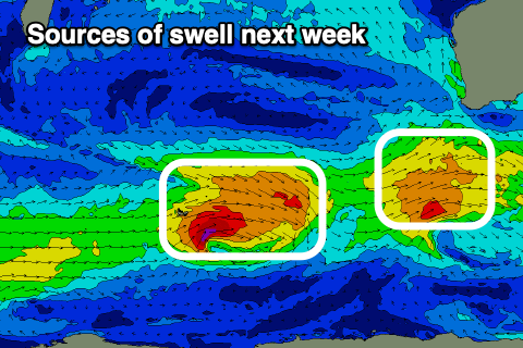
Moving into next week and Monday looks smaller with S/SE-S/SW breezes, while come Tuesday, the first of back to back pulses of mid-period SW swell followed by groundswell energy later Wednesday/Thursday is expected.
This will be thanks to back to back frontal systems moving in from the Heard Island region with the first forecast to generate a healthy fetch of strong W/SW winds, followed by a stronger secondary system generating persistent gales.
The first looks moderate in size with the second coming in a bit stronger. Winds early week look favourable before tending S'ly but we’ll confirm this Friday.