Poor end to the week, better weekend
Western Australian Forecast by Craig Brokensha (issued Wednesday November 20th)
Best Days: This morning in the South West, Saturday morning in the South West, Sunday morning all regions, Thursday next week
Features of the Forecast (tl;dr)
- Strong SW-S/SW winds tomorrow, fresher Fri (possibly S/SE early Perth/Mandurah)
- Moderate sized mid-period SW swell building Sat PM, easing Sun
- E/SE tending S/SW winds Sat, fresh SE tending S/SW Sun
- Strong S/SE-S/SW winds early next week with smaller swells
- Large SW groundswell building later Wed, peaking Thu with gusty E/NE-NE tending N winds
Recap
An inconsistent SW groundswell filled in yesterday providing windy, 4-6ft surf across the South West with the metro regions building to 1-2ft through the day but with increasing bumps from northerly breezes.
This morning the metro locations were still wind affected and not great while lighter winds are providing cleaner conditions across the South West along with a smaller, easing 3-5ft of swell.
This week and weekend (Nov 21 - Dec 1)
As Steve pointed out in Monday’s notes, we’ve got an active train of frontal systems moving through the Roaring 40’s but none of them are overly significant. This will result in small to moderate levels of swell for the period with poor winds to end off the week as a low that’s formed west of is pushes east through today.
This looks to bring fresh to strong SW-S/SW winds to all locations tomorrow with some weak, localised windswell, weaker but persisting from the S/SW on Friday. There’s a good chance for early S/SE winds across Perth/Mandurah but the swell looks to be 1-2ft max and weak.

Into the weekend cleaner conditions are due as winds shift E/SE along with background levels of mid-period swell in the 4ft range across the South West Saturday morning, tiny to the north.
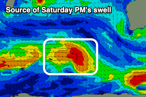
Into the afternoon, a better pulse of swell is due, generated by a small low currently sitting north-east of the Heard Island. While not overly strong it is persistent and this should provide a kick in size to 4-5ft+ across the South West Saturday afternoon with 1-2ft sets later to the north, easing Sunday from 4-5ft and 1-2ft respectively.
Sea breeze will spoil this swell across most spots, with SE winds due into Sunday morning as it eases across the South West, more E/NE to the north.

Looking at next week and the start looks to be generally small and windy as a trough deepens along the coast, bringing strong S/SE-S/SW winds Monday/Tuesday.
Of greater significance is a strong polar low that’s forecast to form around the Heard Island region this weekend. A great fetch of storm-force winds should produce a large, long-period SW groundswell for later Wednesday, ahead of a peak Thursday with what looks to be E/NE-NE winds. We’ll take a closer look at this on Friday though.

