Slower period with smaller swells
Western Australian Forecast by Craig Brokensha (issued Friday October 25th)
Best Days: Sunday morning, Monday morning in the South West, Tuesday morning
Features of the Forecast (tl;dr)
- Small, building SW swell today
- Moderate + sized mid-period SW swell building tomorrow PM, peaking later, easing Sun
- S/SE tending strong S/SW-SW winds tomorrow, E/SE-SE Sun AM ahead of sea breezes
- Small-mod sized SW swell Sun PM, easing Mon with fresh E tending S/SW-SW winds
- Moderate + sized mix of SW groundswells Tue with E/SE winds in the South West, E/NE to the north ahead of a strong S-S/SW change into the PM
- Easing swell Wed with gusty S/SE winds, smaller Thu with E/SE winds
Recap
The swell backed off yesterday as conditions cleaned up across the South West with clean, easing 4-5ft sets across the magnets, smaller and to 1-2ft to the north.
Today is even smaller and peakier with a cross-shore wind and low point in swell.
This weekend and next week (Oct 25 - Nov 1)
There’s no change to the weekend’s outlook with a small increase in mid-period swell this afternoon due to hold tomorrow ahead of a better increase in size through the afternoon (late to the north), easing Sunday.
The timing isn’t ideal as all regions are due to start off small and with less than ideal S/SE winds, shifting S/SW with strength into the afternoon as the new swell arrives.
Building sets to 4-6ft are due in the South West tomorrow, 2ft in Mandurah and 1-2ft Perth before easing slowly Sunday from a slightly smaller size but with better E/SE-SE offshore winds.
A small reinforcing SW swell is due Sunday afternoon, easing Monday again with offshore E winds across the South West ahead of sea breezes.
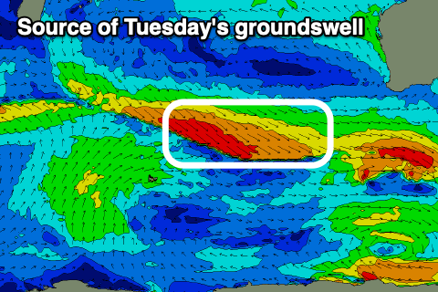
Later in the day but more so Tuesday a better increase in groundswell is due, but the size has been downgraded since Wednesday.

The source of pre-frontal W/NW gales will be just that and won’t reach severe-gale resulting in a moderate + sized increase in energy Tuesday, hitting 4-6ft across the South West, 1-2ft max on the sets in Mandurah and 1-1.5ft in Perth.
There'll also be a similar sized, less consistent groundswell signal in the water at the same time, generated by a distant storm south-east of South Africa.
Conditions will be good again though with an E/SE offshore in the South West, E/NE to the north ahead of a strong afternoon/evening S/SW-S change as a trough moves through.
This will leave strong S/SE winds into Wednesday as the swell eases.
The surf will continue to fade into the end of the week as winds improve Thursday, going variable Friday ahead of a strong frontal system next Saturday.
Swell wise, there’s nothing significant due at all so make the most of the cleaner conditions and moderate sized swell pulses this period. Have a great weekend!

