Great surf developing through the week, XL swell next week
Western Australian Forecast by Craig Brokensha (issued Monday October 7th)
Best Days: This morning, protected spots Wednesday, Thursday, Friday
Features of the Forecast (tl;dr)
- Easing surf tomorrow with variable winds early ahead of an onshore change
- Large W/SW groundswell filling in Wed (undersized early), with a reinforcing SW groundswell for Thu AM
- Strong S/SE winds Wed, E/SE Thu AM ahead of late sea breezes
- Moderate + sized reinforcing SW groundswell for Fri PM with fresh E/NE tending weaker N winds
- Smaller Sat with strong S/SW winds, easing Sun with E/SE tending S/SW winds
- XL, long-period W/SW groundswell possibly showing on dark Mon, peaking Tue with strong W/NW winds
- Easing swell Wed with strong W/SW winds
Recap
The metro regions offered fun surf all weekend with 2-3ft of swell both Saturday and Sunday morning, with light onshore winds yesterday morning not making much of an impact on the quality.
Today some reinforcing swell energy is maintaining 2ft sets across Perth (a little better than expected) with lumpy 4-5ft waves across the South West as winds finally eased and tended light offshore.
This week and next (Oct 8 - 18)
Today’s small lift in reinforcing groundswell is due to ease back through tomorrow and early variable winds will shift onshore during the morning as our large, swell producing frontal progression moves in slowly from the west.
What we’re seeing is a good fetch of W’ly gales being slowly projected east through our western swell window, with a secondary fetch of W/SW gales through our south-western swell window today and tomorrow due to generate some secondary SW groundswell Thursday after the initial W/SW pulse Wednesday.

Size wise, both swells should come in around 8-10ft across the South West from Wednesday (undersized early) through Thursday morning with Mandurah coming in at 3ft+ with 2-3ft sets in Perth.
A high will move in behind tomorrow’s onshore change, with gusty S/SE winds due on Wednesday, favouring protected spots with Thursday still looking great under a fresh, offshore E/SE breeze.
Friday will be good as well with an E/NE offshore but easing swell during the morning, reinforced by a new pulse of SW groundswell into the afternoon. This will be generated by a tight, trailing low behind the main swell producer and should pulse back to 6ft+ in the South West with 2ft sets across Mandurah/Perth as winds tend more variable from the N’th.
The weekend looks generally small and with average S/SW winds on Saturday as a trough moves through, with a return to offshore winds Sunday but with smaller surf.

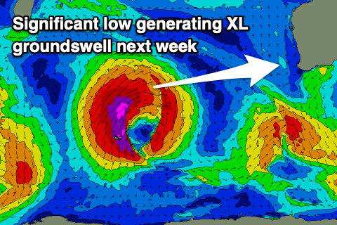
Of more significance is a very strong polar low forming south-east of South Africa later this week, with it due to generate a fetch of severe-gale to storm-force W/SW tending SW winds as it slowly expands east.
An extra-large, long-period W/SW groundswell is due from this source, with it arriving later Monday, peaking Tuesday across the state. Unfortunately the remnants of the storm looks to move in and across us when the swell peaks, bringing strong W/NW winds, with W/SW breezes into Tuesday as it eases.
We’ll have a closer look at this and confirm the finer details on Wednesday and Friday.

