Nothing special for the weekend, better next week
Western Australian Forecast by Craig Brokensha (issued Friday October 4th)
Best Days: Perth/Mandurah tomorrow morning, Monday morning Margs and Mandurah, Thursday morning all locations
Features of the Forecast (tl;dr)
- Moderate + sized reinforcing SW swell tomorrow with W winds in the South West, variable E/NE-NE to the north in the AM
- Easing swell Sun with SW winds
- Smaller Mon AM ahead of a new swell for the PM
- E/SE tending S/SW winds Mon
- Easing swell Tue with S/SE winds
- Large W/SW groundswell Wed with S/SW winds, easing slowly Thu with morning E/SE winds
Recap
Large, stormy, windy surf dominated all locations yesterday with the wind and swell easing a touch into today though not enough to offer up any quality across the regions.
This weekend and next week (Oct 5 - 11)
As touched in the forecast updates earlier this week, the South West will unfortunately see persistent W’ly onshore winds both tomorrow and Sunday. It’ll be weaker than the last two days and only moderate in strength during the morning, but enough to spoil conditions.

Perth and Mandurah should see variable E/NE-NE winds ahead of sea breezes tomorrow and there should be fun amounts of reinforcing SW swell in the mix. This has been generated by trailing frontal activity in the wake of the severe low, and we should see 2-3ft sets persisting across both Perth and Mandurah, easing Sunday from a similar size in Mandurah, 2ft+ in Perth.
Sunday now looks a bit dicey across all locations with the easing swell as a front clips the state bringing SW winds.
Monday still looks clean though with an E/SE offshore across all locations and temporary low point in swell ahead of a new W/SW groundswell arriving through the day.
No major size is due, with the source being a tight but intense, short-lived low firing up north of the Heard Island region yesterday.
The South West may come in at 4-5ft with 1-2ft sets in Mandurah, 1-1.5ft across Perth.
Tuesday looks smaller with fading levels of swell and a shift in winds back to the S/SE during the morning.
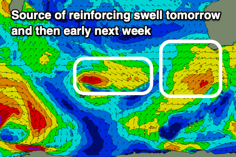
We then look to our larger W/SW groundswell due into Wednesday/Thursday, generated by healthy progression of storms through the southern Indian Ocean over the coming days.

Fetches of W’ly gales followed by a broader, weaker fetch of strong W/SW winds should produce an extended pulse of W/SW groundswell that’s due to arrive overnight Tuesday, peaking through Wednesday, with the mid-period swell for Thursday.
The South West should come in at 8-10ft with 2-3ft sets across Mandurah, 2ft+ in Perth.
Winds look strong out of the S/SW on Wednesday with great E/SE offshore winds Thursday as it starts to ease back from a slightly smaller size. We’ll confirm this on Monday though.
Following this, another smaller pulse of W/SW groundswell is due later Friday/Saturday but we’ll have a closer look at this Monday. Have a great weekend!

