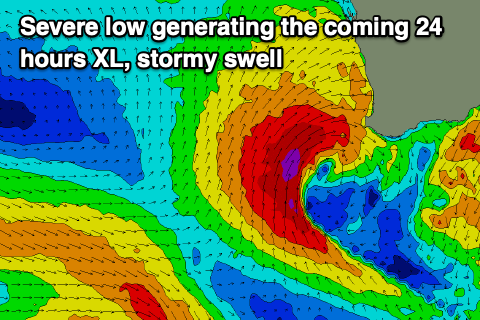
XL stormy swell with poor conditions
Western Australian Forecast by Craig Brokensha (issued Wednesday October 2nd)
Best Days: Perth/Mandurah Saturday and Sunday mornings, Wednesday morning Perth/Mandurah, Thursday week all locations
Features of the Forecast (tl;dr)
- XL stormy W/SW-SW swell for later today and tomorrow AM, easing
- Strong but slowly easing SW tending W/SW winds tomorrow
- Strong W/SW winds Fri
- Reinforcing moderate + sized, mid-period SW swell for Sat and Sun AM, easing
- Lingering SW winds on Sat in the South West, W on Sun
- Variable S/SE winds Sat AM in Perth/Mandurah, light E/NE Sun AM
- Smaller Mon with W winds in the South West, S/SE to the north
- Large W/SW groundswell building later Tue, peaking Wed with strong W/SW-SW winds in the South West, possibly variable to the north
- Easing swell Wed with E/SE offshore winds
Recap
Conditions were nice and clean yesterday morning with plenty of swell in the 6ft+ range across the South West, 2-3ft Mandurah and 2ft in Perth. Conditions deteriorated throughout the day with sea breezes while today a strong onshore change has moved through with heavy rain.
This week and next (Oct 3 - 11)
Today’s strengthening winds which will reach gale-force on the gusts across the South West are thanks to a severe low that’s developed west of us. This low will move in slowly through today with a fetch of severe-gale to storm-force S/SW winds being aimed primarily at central and northern regions of the state.

The low will move in this evening and early tomorrow, bringing with it an XL, stormy W/SW-SW swell that looks to reach 15-20ft in the South West, easing through the day with stormy 6ft surf across Mandurah, and 4-5ft in Perth.
Strong but easing SW tending W/SW winds won’t really offer anything in the way of quality, with Friday seeing smaller surf but persistent, strong W/SW winds.
As touched on on Monday’s notes, the start of the weekend looks to still remain onshore with SW winds across the South West, but variable tending S/SE breezes are likely around Perth and Mandurah.
Size wise, some good, new mid-period SW swell is due to be in the water Saturday, followed by a secondary stronger (period wise) pulse on Sunday.
These swells will be generated by weak, trailing frontal systems moving in behind the severe-low, generating fetches of strong W-W/SW winds.
Saturday’s swell should come in around 2-3ft across Perth and Mandurah, with Sunday easing back from 2-3ft in Mandurah, 2ft+ Perth with Margs due to come in at 6ft+.
Unfortunately lingering W’ly winds will continue to add unwanted bumps to the South West on Sunday morning, lighter E/NE from Mandurah north during the morning (NE Bunbury).

Smaller surf is then due into Monday with lingering W’ly winds across Margs, S/SE to the north.
Our next pulse of swell looks to build through late Tuesday, peaking Wednesday, generated by a healthy mid-frontal system rolling in through the southern Indian Ocean on the weekend/early next week.
Winds look an issue again when it peaks on Wednesday morning to the 10ft+ range across the South West with 3-4ft surf across Mandurah and 2-3ft waves in Peth, with Thursday being the pick as the swell eases and high pressure moves in, bringing offshore breezes. We’ll confirm this on Friday.

