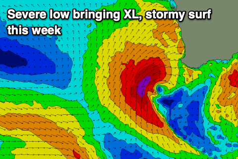
XL stormy swell this week
Western Australian Forecast by Craig Brokensha (issued Monday September 30th)
Best Days: Tomorrow morning, Sunday morning, Monday
Features of the Forecast (tl;dr)
- Moderate sized mid-period SW swells tomorrow with light E/SE-SE tending SW winds
- Strong N/NW tending W/NW, then likely gale-force winds Wed with large building levels of stormy swell
- XL stormy swell peaking Thu AM, easing steadily with strong but easing SW winds
- Easing swell Fri with mod-fresh W/SW winds
- W/NW winds Sat with moderate levels of swell
- Moderate sized mid-period SW swell Sun with variable winds ahead of sea breezes
- Easing swell Mon with E/NE NW winds
Recap
The South West was onshore and mostly average to poor all weekend with small, peaky/lumpy offerings across the metro regions to 1-2ft both Saturday and Sunday, cleanest yesterday.
Today we’ve got some new mid-period swell on the build with cleaner but still lumpy conditions across the South West, better further north and to a fun 1-2ft.
We should see the swell building further through the day ahead of a peak tomorrow, but more on this below.
This week and weekend (Oct 1 - 6)
We’re currently seeing a mid-period SW swell on the build across the region, generated by a healthy but not overly strong mid-latitude frontal system projecting up and under us.
An initial increase is being seen today with a secondary reinforcing pulse for tomorrow afternoon, easing into Wednesday.
The South West should see 6ft waves with 2ft+ surf across Mandurah, 2ft in Perth along with a light E/SE-SE offshore wind ahead of sea breezes.
Make the most of this window as come Wednesday we’re set to see strengthening N/NW winds from the get go, shifting W/NW during the morning and then strengthening further into the afternoon.

This will be linked to our northward projecting, severe mid-latitude system firing up immediately west of us tomorrow evening and Wednesday.
We’re now set to see the swell generating fetch sit more in our swell window, with a fetch of severe-gale to storm-force S/SW winds due to project towards the central parts of the state Wednesday before moving across the South West into the evening.
This will see an XL, stormy swell produced for all locations, building Wednesday afternoon/evening, peaking early Thursday morning to 15-18ft+ with 6ft waves in Mandurah and 4-5ft surf across Perth, dropping rapidly through the day. Strong but abating SW winds will accompany the swell with limited options for a surf, while Friday looks to see persistent, moderate to fresh W/SW breezes as the swell continues to drop.
Unfortunately it looks like lingering frontal activity will continue to bring onshore winds to all regions on Saturday, possibly easing into Sunday and with moderate + levels of reinforcing mid-period energy.
The stream of westerly winds should produce a peak in swell Sunday to the 5-6ft+ range in the South West, 2ft Mandurah and Perth, easing Monday with E/NE offshores very likely. More on this in Wednesday’s update.

